

, OH
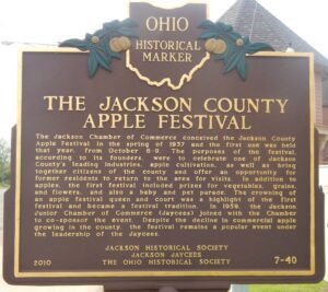
The Jackson Chamber of Commerce conceived the Jackson County Apple Festival in the spring of 1937 and the first one was held that year, from October 6-9. The purposes of the festival, according to its founders, were to celebrate one of Jackson County’s leading industries, apple cultivation, as well as bring together citizens of the county and offer an opportunity for former residents to return to the area for visits. In addition to apples, the first festival included prizes for vegetables, grains, and flowers, and also a baby and pet parade. The crowning of an apple festival queen and court was a highlight of the first festival and became a festival tradition. In 1959, the Jackson Junior Chamber of Commerce (Jaycees) joined with the Chamber to co-sponsor the event. Despite the decline in commercial apple growing in the county, the festival remains a popular event under the leadership of the Jaycees.
, OH
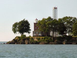
Constructed and first lit in 1897, the South Bass Island Light was in continuous operation until 1962 when the U. S. Coast Guard built an automated light tower to replace it. Significant for its contribution to transportation and commerce on Lake Erie, the South Bass Island Light was built to safely guide vessels through the crowded South Passage. Although many light stations were constructed with a dwelling as a separate structure, the keeper’s dwelling of the South Bass Light was attached to the 60-foot tower. The dwelling was designed in the Queen Anne style with red brick laid in Flemish bond. Outbuildings, a barn and oil house, were built in 1899. In 1967, The Ohio State University acquired the property for support of the F. T. Stone Laboratory programs for research, education, and outreach. South Bass Island Light was placed on the National Register of Historic Places in 1990.

, OH
This Queen Anne style building with segmental-arched windows and steep hipped roof was Burton’s second high school. Completed in 1885 at a cost of $12,500, it is wood framed with a brick and stone exterior, modeled after an academy in River Falls, Wisconsin. Its basement and two upper floors contained 12,720 square feet of space, enough for all twelve grades. There were two separate entrances; girls entered on the left and boys on the right. Electricity was installed in 1921 by the superintendent and students. Classes met here until 1936. During its history, the building housed various organizations, including the Red Cross, Opportunity School of Geauga County (later Metzenbaum), Geauga County Historical Society, American Legion, and County Extension Office. In 1937, it became the home of the Burton Public Library and in 1983 was expanded with a north wing designed to be architecturally consistent with the original 1885 structure.
, OH
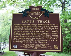
Fulfilling President George Washington’s desire to “open wide the gates of the West,” in 1796 Congress authorized the Zane brothers of Fort Henry (at present day Wheeling) to clear a path through the dense woods of Appalachian Ohio. Zane’s Trace cut through the forests of eleven counties, reaching the Ohio River at Aberdeen, across from Limestone (now Maysville), Kentucky. The trail roughly follows the routes of U.S. 22 and 40 to Lancaster, S. R. 159 to Chillicothe, U.S. 50 to Bainbridge, and S. R. 41 to Aberdeen.
, OH
Lake Erie commerce has played a central role in the development of Huron. Important among Huron’s maritime industries were shipbuilding and commercial fishing. The city’s shipbuilding industry dates to the first decades of the nineteenth century. Shipyards were located on the Huron River’s west bank, slightly north of this marker, and also upstream at Fries Landing. Among the vessels built at Huron were the Great Western, constructed in 1838 and the first lake ship to have above-deck cabins, and the Golden Age, which, at 286 feet, was the largest craft on the Great Lakes when built in 1886. Huron shipbuilding declined as the nineteenth century drew to a close. Commercial fishing emerged thereafter, serving as Huron’s economic cornerstone for over fifty years. Huron’s fishing enterprises included the Huron, Kishman, Scott, and Zimmerman fish companies. By 1950, however, polluted lake waters ravished the once-lucrative industry. Although shipbuilding and commercial fishing are no longer a part of Huron’s daily life, they each had a profound effect upon the community’s growth for nearly two centuries.
, OH
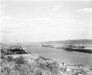
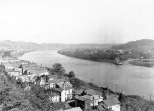
The Ohio River, the southeast border of Gallia County, played a significant role in the development of Gallipolis and Gallia County. One of the state’s first thoroughfares, this waterway enabled pioneers to settle in what was known as the Northwest Territory. On October 17, 1790, approximately 500 French immigrants arrived in Gallipolis, traveling by flatboats from Pittsburgh, and settled in log cabins in what is now City Park, in the heart of Gallipolis. This established the second oldest permanent settlement in the territory. The settlers relied on the River for communication, commerce, and transportation, and the River brought postal service to Gallipolis in 1794. As local business and river trade developed in the 1800s, Gallipolis became a thriving port. The scenic Ohio River is an important inland waterway, providing transportation for many commodities between major cities. The River also provides recreational opportunities for both visitors and residents, including water sports, fishing, and boating.
, OH
Officially opening on August 4, 1840, the Pennsylvania and Ohio Canal followed the route of present railroad tracks through Munroe Falls approximately one thousand feet south of this marker. This 82-mile long "feeder canal" connected the Beaver Valley canal system at New Castle, Pennsylvania with the Ohio and Erie Canal in Akron, thereby linking Pittsburgh with Cleveland and the western Great Lakes. Many communities along the canal’s path became linked to national and world commerce through their establishment as canal ports. New England investor Edmund Munroe purchased property and water rights along the canal’s proposed route, and in 1837 established the Munroe Falls Manufacturing Company. The village of Munroe Falls grew around the manufacturing company site and was incorporated on October 26, 1838. When this section of the canal closed in 1869, the waterway through Munroe Falls was filled and railroad tracks were laid over its path. A portion of the canal bed is still visible east of State Route 91.
, OH
The Ohio River begins at the confluence of the Allegheny and Monongahela rivers in Pittsburgh, Pennsylvania, and flows 981 miles to join the Mississippi River at Cairo, Illinois. The Iroquois called the river “Oyo” or “Ohio,” which the French translated as “La Belle Riviere,” the Beautiful River. It was an important transportation route for countless generations of Native Americans and, beginning in the 1780s, for Euro-American settlers. It was the main route to the opening West and the principal outlet for the region’s growing farm output. Congress first acted to improve navigation in 1824 and, later, by canalizing the river with a series of locks and dams beginning in 1878. River commerce has increased with industrialization, moving up to 150 million tons annually.