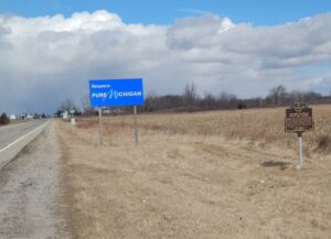
In 1772-73 missionary David Jones visited Blue Jacket’s Town, a settlement of 12 cabins downstream on the east bank and Pickaweekee, a Shawnee town, on the west bank. Deercreek Methodist Circuit Deacon, Dr. Edward Tiffin, met settlers after 1798. Dr. Tiffin was later elected first governor of Ohio. A station of Virginia bounty-land settlers, “Williams Town,” assembled here around 1797. Mill sites, established before Pickaway County, flourished in the dense oak forest of Deercreek Township. Frontier hotels in Williamsport prospered due to the “healthful” sulphur springs.
The landscape of northwest Ohio was formed by melting ice and the glacial lakes left behind in its wake. Because of the low gradient (3 feet fall per mile) to the northeast, the flat lacustrine plain evolved into a large swamp. A massive swamp forest with huge hardwoods, broken only sporadically with intermittent wet prairies and savannahs, dominated the landscape. Both prehistoric and historic Indians farmed the flood plains of the Maumee River and its tributaries: Auglaize, Tiffin, and Blanchard rivers. (continued on other side)
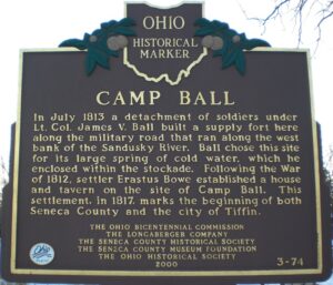
In July 1813 a detachment of soldiers under Lt. Col. James V. Ball built a supply fort here along the military road that ran along the west bank of the Sandusky River. Ball chose this site for its large spring of cold water, which he enclosed within the stockade. Following the War of 1812, settler Erastus Bowe established a house and tavern on the site of Camp Ball. This settlement, in 1817, marks the beginning of both Seneca County and the city of Tiffin.
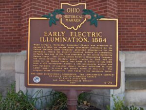
When St. Paul’s Methodist Episcopal Church was dedicated on January 6, 1884, an ornate brass chandelier presented by the Edison Electric Light Company provided illumination for the ceremony. Wired for electric lighting before its completion, St. Paul’s was one of the first churches in the nation lighted by Edison lamps. The Tiffin Edison Electric Illuminating Company, the first central electric power station in Ohio and the tenth in the United States, was built in Tiffin in late 1883. With a 100 horsepower boiler, a 120 horsepower engine, and two dynamos, it supplied direct current sufficient to light 1,000 lamps. It stood two blocks north of this site. The original brass “electrolier” still hangs in the sanctuary inside.
After the War of 1812, the United States Congress proposed two million acres of military bounty land for the Michigan Territory. To survey the land, the meridian had to first be established. U.S. Surveyor General Edward Tiffin created the meridian based on the western line of the Treaty of Detroit (1807). He contracted with Deputy Surveyor Benjamin Hough in April 1815 to begin the survey for $3 per mile. Taking a reading from Polaris (the North Star), Hough, Alexander Holmes, and 11 crew members surveyed the line due north from Fort Defiance. The difficult terrain they encountered temporarily halted all surveys in the territory and ultimately led to the bounty land being transferred to the Illinois and Missouri Territories.
Evansport is named after brothers Amos and Albert G. Evans who, with Jacob Coy, had the village surveyed next to the Tiffin River on December 14, 1835. The “port” suffix in Evansport’s name reflects the river’s significance as a transportation thoroughfare. Evansport’s early growth was spurred by its mills powered by the Tiffin River. The mills provided settlers with lumber for buildings and supplied flour and cornmeal for sustenance and commerce. Settlers who poured into Williams County’s northern townships in the 1830s agitated debate about moving the county seat to a more centralized location. Evansport was platted as a possible site for the county seat. The Williams County seat was moved to Bryan in 1840 and in 1845 Defiance County was created, leaving Evansport on the Williams-Defiance county line.
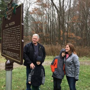
Two Deputy U.S. General Land Office Surveyors traversed Goll Woods: Benjamin Hough in 1815 and Captain James Riley in 1821. Hough (1772-1819) established the Michigan Meridian in 1815 and was county and state office holder in Ohio. Riley’s life was more tumultuous. Riley (1777-1840) captained the merchant ship Commerce, which wrecked off the Saharan coast in 1815. Riley and crew were enslaved for four months until ransomed by British diplomat William Willshire. In 1817, Riley published a famous account of his time in North Africa, and, in 1819, was appointed a surveyor by Surveyor General Edward Tiffin. Moving to Northwest Ohio, Riley named the village he founded in 1822, Willshire, for his deliverer. Riley returned to New York in 1826 and to the sea, where he died. Riley’s book went through more than twenty editions by 1860 and Abraham Lincoln credited the account as one that influenced him deeply.
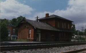
By the mid 1830s, Ohio had developed a canal system that linked Lake Erie in the north to the Ohio River in the south. Despite the success of the canals, transportation companies searched for other methods to traverse the state. They found their answer in the railroad industry, which proved to be much faster, cheaper, and more reliable than canals. Located on Lake Erie, Sandusky, Ohio was a major trading depot in the area. Plans were made to connect Sandusky to Cincinnati’s port on the Ohio River. On September 4, 1835, construction began in Sandusky on the Mad River and Lake Erie Railroad line, forming the first railroad line located entirely in Ohio. The railroad reached Tiffin by 1841 and Springfield by 1848, where it merged with the Little Miami Railroad line, connecting Lake Erie to the Ohio River.