Sounds of boat horns and brawling packet crews resounded for many years at this lock and 142 others on the Ohio and Erie Canal. The canal was a 308-mile water toll road built between 1825 and 1832 from Lake Erie at Cleveland to the Ohio River at Portsmouth. The early growth of Akron and Massillon was due to the canal. Railroads caused its decline and the flood of 1913 destroyed its usefulness.
The Silver Creek Cheese Factory was located in the heart of the tri-county area known during the 19th century as “Cheesedome”. This part of the Western Reserve was best known for the cheese it shipped internationally. The factory contributed to the Aurora processing network, which by 1904 was shipping 4,000,000 pounds of cheese per year. The factory was destroyed by a flood in 1913 as were many other industries which flourished in the Chagrin Valley.
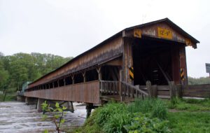
Replacing an earlier bridge that was carried away in a spring flood, the Harpersfield Covered Bridge was built in 1868 and spans the Grand River, a state-designated wild, and scenic river. This bridge, which currently carries County Road #154 (Harpersfield Road), is a two-span wooden Howe truss bridge, with center pier. The great flood of 1913 washed away the northern approach and it was at this time that the additional 140 foot steel truss was added. Extensive rehabilitation in 1992 included strengthening the lower chords, lowering and replacing the floor, and adding a cantilevered walkway. The 228-foot-long Harpersfield Bridge is the longest covered bridge in Ohio and is on the National Register of Historic Places.
Plunging herds of buffalo seeking salt licks and grazing lands wore trails through the Ohio Country when it was an Indian no-man’s land. Later, Indians found the same trails suitable for their needs. The tawny paths were highways as well as highest ways. Indians found ridges and summits superior to valleys for trails because they were drier, windswept of snow, never clogged by flood debris and safer.
The landscape of northwest Ohio was formed by melting ice and the glacial lakes left behind in its wake. Because of the low gradient (3 feet fall per mile) to the northeast, the flat lacustrine plain evolved into a large swamp. A massive swamp forest with huge hardwoods, broken only sporadically with intermittent wet prairies and savannahs, dominated the landscape. Both prehistoric and historic Indians farmed the flood plains of the Maumee River and its tributaries: Auglaize, Tiffin, and Blanchard rivers. (continued on other side)
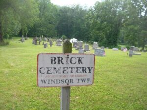
The Windsor Township Baptist Association was organized January 11, 1818 by Elder William Davis with 35 members who met in homes, barns and schoolhouses. At the death of the six-year-old granddaughter of Samuel and Tabitha Davis Henery, this plot by the river was laid out of a church yard and deeded by John Henery in 1837. In 1838 a brick church was built at the cost of $1,000. It served this community until the road and church were destroyed by the flood of 1913. More than 50 men from this area served in the Civil War. Twenty-six War of 1812 veterans are buried here as well as William Davis, veteran of the American Revolution; Obadiah Brokaw, founder of Big Bottom State Memorial; and Captain Isaac Newton Hook, river pilot at the age of ten and U.S. master of inland navigation, 1860-1873, who ran supplies on the Tennessee and Cumberland rivers for the Union Army. At Captain Hook’s death in 1906, the steamers Valley Gem, Zanesville, and Sonoma from Marietta in his honor landed passengers at the church here for his funeral, “largest ever held in the Muskingum Valley.” “The Lord and the River giveth and then taketh away.”
Digging of the Ohio-Erie Canal began in 1825, and the first canal boat navigated the Deep Cut at Licking Summit in 1831. The surrounding swamps were drained to create the Licking Reservoir, today known as Buckeye Lake, in order to supply adequate water for the canal going north to Coshocton and south to Circleville. After the canal route was established, the state engineers discovered that there was a ridge of hills located south of the proposed reservoir through which they would have to cut the canal. Since it was impossible to raise the level of the reservoir, the ridge had to be cut down to the level of the reservoir. This “Deep Cut” marks the deepest part of the canal at 32 feet and runs south from Millersport for nearly two miles. Unskilled laborers, primarily Irish immigrants, tirelessly dug the canal using picks, shovels, wheelbarrows, and oxen-cart.
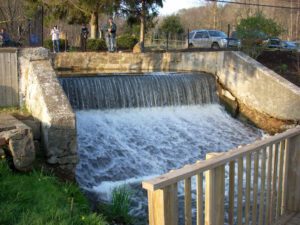
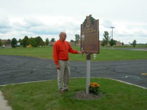
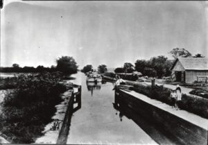
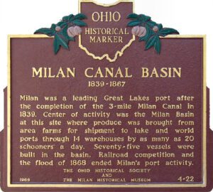
Milan was a leading Great Lakes port after the completion of the 3 mile Milan Canal in 1839. Center of activity was the Milan Basin at this site where produce was brought from area farms for shipment to lake and world ports through 14 warehouses by as many as 20 schooners a day. Seventy-five vessels were built in the basin. Railroad competition and the flood of 1868 ended Milan’s port activity.