

, OH
Lowell was the site of one of ten wooden covered bridges, built from 1820 to 1887, that crossed the Muskingum River from Marietta to Coshocton. The Lowell bridge was built in 1881. Bridges were built out of wood because there was plenty of lumber available, and building with wood was easier and cheaper than using stone. Covers protected the timbers from rain. The bridge connected Lowell, on the north side of the river, with the railroad that ran on the south side. This bridge suffered from many mishaps typical of wooden bridges. In 1882 a severe storm blew off the roof. In 1884 a flood washed the bridge off its stone piers. The bridge was restored, only to be destroyed by the 1913 flood, a disaster that removed many bridges on the river. An iron bridge was built on the site. The last covered bridge on the river was at Conesville seven miles south of Coshocton. Built in 1876, the bridge was condemned in 1958 and destroyed by a controlled fire.

, OH
In the heyday of steamboating on the Muskingum, many people made their livelihood on the river. Jane McMillan, known as Old Jane, was one of the few women reported to have piloted boats on the river. In the 1840s she was co-owner of the “Zanesville Packet.” McMillan worked a variety of jobs, from cook to pilot. She was reported to know the twists and turns of the river so well that she could navigate safely at night, something many pilots refused to do. Isaac Newton Hook, a descendant of the earliest settlers in Zanesville, used skills he learned on the Muskingum River as a pilot on the Mississippi during the Civil War. He shipped supplies needed by the Union army. His tomb is in the Brick Church cemetery between Hooksburg and Stockport. He had the grave built out of concrete and above the level of the 1898 flood. The 1913 flood submerged the tomb, but it survived and can be viewed to this day.
, OH
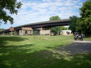
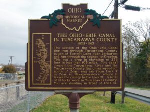
Seeking an alternative transportation route to distant markets, many farmers and manufacturers in Ohio wanted to connect the Ohio River to Lake Erie with a canal. Beginning in Cleveland the Ohio-Erie Canal ran south, the length of the state, to Portsmouth. The canal was a total of 308 miles long, 40 feet wide at the surface, and 4 feet deep. The Ohio-Erie Canal opened for traffic along its entire length in 1832 and consequently effected great change. Population along the canal increased, and commercial, political, and industrial growth in Ohio boomed. Products grown and manufactured in this previously isolated region now had access to world markets. Profits for farmers and merchants increased, and the entire state economy was bolstered. With the rise of railroads in the 1860s, however, canals were destined to become obsolete because the railroad was a faster and more dependable means of transportation. The canal system ceased to operate altogether after a disastrous flood in 1913.
, OH
Completed in 1837, the limestone lock nine served as a catalyst for the growth of Piqua. The lock helped connect the village to Cincinnati (1837) and Toledo (1845) by way of the Miami and Erie Canal. German immigrants traveled up the canal from Cincinnati and settled within a five-block area of the lock. Industries used the lock as a source of water power and developed products as diverse as flannel, flour, and flax seed. Lock nine remained as a functioning part of the canal until its destruction during the flood of 1913.
, OH
Zenas King (1818-1892) was a 19th century bridge builder whose iron bridges received wide acceptance throughout the country. He developed his tubular bowstring bridge in 1859, patented the design in 1861, renewed the patent in 1867, and founded King Iron Bridge & Manufacturing Company in 1871. Based on an arch’s inherent strength, King’s design used less raw materials than wooden bridges and the square tubes were simple to fabricate and ship for on-site assembly. His Cleveland-based company soon built so many patent bowstrings across Ohio that it set a design standard. (Continued on other side)
, OH
This hamlet, located one mile southwest from here, was never platted, but was named after William Woods, president of the three-story brick Woodsdale paper mill constructed in 1867. Flanking the mill were the company office and store and several workers’ houses. Previous to this, the area flourished from the presence of two grist mills on the Great Miami River and from the Miami & Erie Canal. Additional enterprises such as a stone quarry, ice cutting company, and grain elevator operated here during the late 19th and early 20th centuries. Woodsdale was also known for the Woodsdale Island Amusement Park and the LC&D Railroad depot. The park, established on an island between the Miami & Erie Canal and the Great Miami River in 1891, was the site of picnics, political rallies, a large dance hall, and amusement rides–including a beautiful swan boat. The great flood of 1913 completely destroyed the park.
, OH
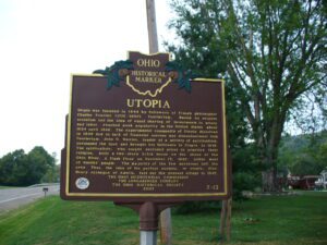
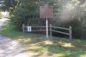
Utopia was founded in 1844 by followers of French philosopher Charles Fourier (1772-1837). Fourierism, based on utopian socialism and the idea of equal sharing of investments in money and labor, reached peak popularity in the United States about 1824 until 1846. The experimental community of Utopia dissolved in 1846 due to lack of financial success and disenchantment with Fourierism. John O. Wattles, leader of a society of spiritualists, purchased the land and brought his followers to Utopia in 1847. The spiritualists, who sought secluded areas to practice their religion, built a two-story brick house on the shore of the Ohio River. A flash flood on December 13, 1847, killed most of Wattles’ people. The majority of the few survivors left the area. Thus, the idea of the perfect society, or utopia, died. Henry Jernegan of Amelia, laid out the present village in 1847.
, OH
After completing Fort Winchester, Brigadier General James Winchester ordered his troops to cross to the north side of the Maumee River. The troops occupied the new site, Camp #2, from November 3-10, 1812. An earthen fortification was built for protection. Militia soldier Elias Darnell recorded on November 4th that “The weather is very rainy, which makes our situation extremely unpleasant…. Four of this army have gone to the silent tomb to-day never more to visit their friends in Kentucky; the fever is very prevalent in camp; nearly every day there is one or more buried.” Winchester referred to a burial place for the encampment in his General Orders for November 5th. Camp #2 proved to be too wet and marshy, Winchester ordered his army to move to six miles down river to a site called Camp #3.