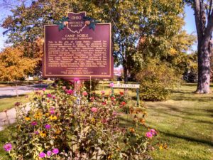
This is the site of Camp Noble, named for Congressman Warren P. Noble, who obtained the officer’s commission for William H. Gibson as the colonel of the 49th Ohio Volunteer Infantry. Companies of 100 began to arrive here August 12, 1861 from Crawford, Hancock, Putnam, Sandusky, Seneca, and Wyandot Counties. On August 20, they were mustered into Federal service as the 49th Ohio Volunteer Infantry. Nicknamed the “Buckeye Vanguard” by Col. Gibson, training continued until September 9, 1861, when the 49th was ordered to Camp Dennison, near Cincinnati, Ohio. (Continued other side)
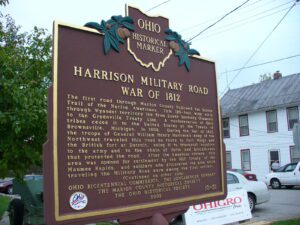
The first road through Marion County followed the Scioto Trail of the Native Americans. This 120-foot wide strip through Wyandot territory led from Lower Sandusky (Fremont) to the Greenville Treaty Line. A confederation of Ohio tribes ceded it to the United States at the Treaty of Brownsville, Michigan, in 1808. During the War of 1812, the troops of General William Henry Harrison’s Army of the Northwest traveled this road en route to Fort Meigs and the British fort at Detroit, using it to transport supplies to the army and to the chain of forts and blockhouses that protected the road. After the American victory, this area was opened for settlement by the 1817 Treaty of the Maumee Rapids, and soldiers who discovered the area while traveling the Military Road were among the first settlers. (continued on other side)
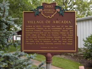
Settled in 1833, Arcadia was one of the last permanent villages to be established in eastern Hancock County. Pioneers Ambrose, David, and Ephriam Peters laid out the farming village on the south edge of “Wild Cat Thicket.” They found the resident Wyandot Indians friendly and helpful. Arcadia was incorporated in 1859. Soon after, the Lake Erie & Western, and the New York Chicago & St. Louis railroads entered the village. (Continued on other side)
Following the American Revolution, the new Federal government, in need of operating funds, sold millions of acres of western lands to land companies. One such company, the Ohio Company of Associates, brought settlement to Marietta in 1788. Two years later, despite warnings of Native American hostility, an association of 36 Company members moved north from Marietta to settle “Big Bottom,” a large area of level land on the east side of the Muskingum River. The settlers were acquainted with Native American warfare, but even so, built an unprotected outpost. They did not complete the blockhouse, put pickets around it, or post a sentry. On January 2, 1791, a war party of 25 Delaware and Wyandot Indians from the north attacked the unsuspecting settlers, killing nine men, one woman, and two children. War raged throughout the Ohio Country until August 1794 when the tribes were defeated at the Battle of Fallen Timbers.
Huron and Erie County are rich in Native American history. During the construction of the nearby Ohio Route 2 bypass, archeologists in 1976-77 uncovered three Native villages and burial sites. The Anderson site, overlooking the Old Woman Creek estuary, contains artifacts dating to the fifteenth century A.D. The site was once a permanent village, with remains of bowls, fire pits, and even traces of food found among its artifacts. The Jenkins site, also near the estuary, was a winter camp for Indians. Excavators there found several pieces of pottery carbon-dated to 1470 A.D. The final dig, the Enderle site — located west of the Huron River — was strictly a burial site. The discovery of European objects in its graves suggests its creation by a more recent people, such as the Delaware or Wyandot Indians. In 1805, Native Americans in the Firelands signed a land cession treaty at Fort Industry (modern Toledo), and in succeeding years were compelled to leave the region.
The house of Ebenezer Zane was built here in 1805. The structure was the meeting place for the First Methodist Quarterly Conference in 1819 where over 300 settlers in the area and about sixty members of the Wyandot tribe came together. Although the cabin was reconstructed in 1997, it is a symbol of harmonious relations between American settlers and the Wyandot in the years before the latter’s removal from Ohio in 1842.
The Moravian Church in America began missionary work among the Delaware and Mohican tribes of North America in the mid-18th century. David Zeisberger, one of the best-known Moravian missionaries, came to the Ohio country with Delaware converts from a mission in western Pennsylvania and founded Schoenbrunn in the Tuscarawas Valley on May 3, 1772. Josua, a Mohican convert and missionary leader, led Mohican and Munsee Christians downriver and settled Gnadenhutten (“Tents of Grace”) on October 9, 1772. Zeisberger served as lead missionary at both villages. By 1775, there was an estimated 200 inhabitants in the village. The British, along with Wyandot and Delaware allies, suspected the Christian Indians of aiding the Americans. To ensure their allegiance to the British, the inhabitants of Gnadenhutten were forcibly removed in 1781 and taken to Captives’ Town on the Sandusky River.
This area of western Hancock County is a part of the Maumee River Watershed known as “Indian Green.” Wyandot Indians chose this area for hunting and ceremonial grounds along the Blanchard River in the 1700s because it was next to the river, yet high enough to avoid frequent flooding. One-half mile east of this location is a Liberty Township cemetery. It is located upon a sand ridge once used as a burial ground by Indians, hence the name “Indian Green.”