OH 376/N. Riverside Drive, between Maple Avenue and 14th Street
McConnelsville
, OH
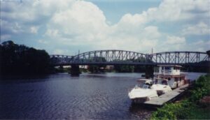
McConnelsville and Malta are two towns that prospered because of the locks and dams built on the Muskingum River from 1836 to 1841. Settlers came to both towns in 1817. In the 1820s and 1830s, flatboats carried grain, lumber, and livestock down the river. The locks and dams made the Muskingum navigable to steamboats, and both towns grew rapidly. Malta was the home of the Brown-Manly Plow Company, a leading maker of farm equipment in the 1800s. Brown-Manly depended on steamboats to bring in raw materials and to take products to markets. Mills at McConnelsville ground grain and shipped flour north to the Ohio Canal and to the east coast, and south to the Ohio River and the Mississippi trade.
This historic inn began serving travelers on the old Portage-Columbiana stage road (now Tallmadge Road) in 1832. Two major stage lines, one from Cleveland to Wellsville (the closest Ohio River port) and the other from Cleveland to Pittsburgh, passed through Palmyra in the early 1800s. Originally a simple two-story Greek Revival-style building, it had its third story added in 1888 when it became a lodge for the Knights of Pythias fraternal organization. It served as a private residence and store for most of the 20th century. The Palmyra Center Hotel was added to the National Register of Historic Places in 1976.
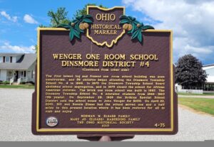
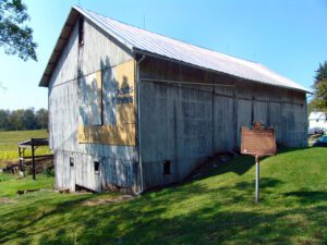
Dinsmore Township School District #4 was formed in 1865following a decision by the township’s board of education that a school would be built in the center of every four sections of land, or every four square miles. This placement of school buildings gave township children the opportunity to attend school close to home and the chance at receiving a public education up to the eighth grade, Nine districts were created for the children of white households, and an additional district was formed to educate the children of the African American families, for a total of ten districts in the township. On June 11, 1866, the Dinsmore Township School Board purchased land from George Wenger to build the District #4 school near the intersection of Ohio Route 274 and Wenger Road. (Continued on other side)
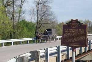
County Road 265 follows an old Indian trail which connected the Wyandot villages at Upper Sandusky with the Shawnee Mac-o-chee towns to the southwest. Many wigwams were pitched near this Scioto River ford during the late 18th and early 19th centuries. Soldiers (during the War of 1812), settlers, and stagecoach passengers later followed this route.
A migration of Indians throughout Ohio began due to unstable conditions created by the American Revolution. The massacre of Christian Indians at the Moravian mission of Gnadenhutten in 1782 and Colonel William Crawford’s expedition against Wyandot and Delaware towns along the Sandusky fueled insecurities. Delaware, including a small group of Mingo Indians, abandoned the village of Helltown, five miles southwest of this site, and settled Greentown as early as 1783. Greentown, situated on an elevation on the Black Fork beyond the clearing behind this site, was presumably named for British loyalist, Thomas Green. John Chapman (Johnny Appleseed) had an amicable relationship with the Delaware, owned land throughout the Black Fork Valley, and was known to visit Greentown on his travels throughout Ohio. Other visitors to the village included the Shawnee Prophet; Munsee Delaware leader, Captain Pipe; and local preacher, James Copus.
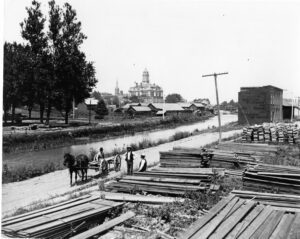
On this site the Ohio & Erie Canal flowed south and down-level under the Market Street Bridge. Nearby Pawpaw Creek and the canal culturally divided the Swiss settlers to the west in Basil and the Virginia pioneers to the east in New Market (Baltimore by 1833). In March 1825, the “Twin Cities” were “dedicated” one day apart and energized a feud that often erupted at the bridge where “the boys of one village entered the other at their peril and where the worst of the intervillage fights were held.” The rivalry stretched well into the twentieth century and was arguably terminated with an uneasy consolidation of the two towns in 1947.
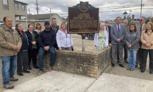
The Caldwell Downtown Historic District is the historic commercial and governmental core of the Village of Caldwell, which was founded in 1857 on farmland owned by Joseph and Samuel Caldwell. Caldwell serves as the county seat of Noble County, the last of Ohio’s 88 counties to be organized. The agricultural community prospered and by 1873 was the second-largest producer of tobacco in Ohio. The Pennsylvania Railroad arrived in 1872, and the development of salt, oil, coal, and natural gas extraction companies followed during the 1880s. Two separate fires in 1897 devastated portions of the north and south quadrants of the district. As a result, Caldwell formed a volunteer fire department and the Village Council introduced legislation prohibiting construction of wood buildings within a block of the public square. (Continued on other side)
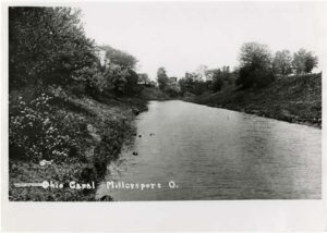
Miami & Erie Canal and Napoleon’s First Cemetery. The Miami & Erie Canal stretched approximately 250 miles from Cincinnati to Toledo. Napoleon and other towns on the Maumee River’s banks were on a slackwater section of the canal. Between 1825 and 1845, laborers constructed the canal using shovels, picks, wheelbarrows, and horse and mule-drawn carts. In Henry County, Napoleon, and elsewhere, German and Irish immigrants and area farmers did the work and were paid around 30 cents a day. As the canal brought more people and business to the area, villages such as Florida, Damascus, and Texas flourished and the county seat of Napoleon boomed. The canal and consequent growth took their tolls, however. Sickness and disease such as “ague” (malaria) and cholera spread and carried off many. Napoleon’s first cemetery was located in the vicinity of 500 East Clinton Street, near the route of the canal.