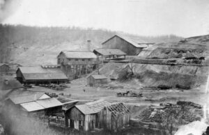
To furnish the needs of the early settlers, then to furnish ordnance for a nation at war, and finally to furnish merchant iron to the steel mills, 100 iron producing blast furnaces were built within these 1,800 square miles of the lower coal measures to become known as the Hanging Rock Region. Lawrence County, centrally located within the Region, had 23 blast furnaces constructed between 1826 and 1909.
Intersection of Mt. Vernon Avenue and LWR Gamiber Road.
Mount Vernon
, OH
Named for the Native Americans who first dwelled here along both sides of the Kokosing River, the Little Indian Fields is adjacent to the site of the first white settlement of Knox County. Early white inhabitants of this land were Andrew and Catherine Craig and Benjamin and John Butler. John “Appleseed” Chapman planted an apple orchard near here at the confluence of the Kokosing River and Centre Run and in 1809 bought two lots in Mount Vernon. In 1808 the Ohio Legislature created Knox County and later designated Mount Vernon as the county seat.
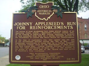
The killing of local shopkeeper Levi Jones stirred rumors of an impending Indian attack. Mansfield’s settlers needed help. On the evening of August 9, 1813, Johnny Appleseed is believed to have embarked from here on a daring overnight journey to the settlements of Clinton and Mount Vernon for reinforcements. At the time of Appleseed’s run, this square was the site of two blockhouses erected during the War of 1812. One blockhouse, constructed of round logs by a Captain Schaeffer of Fairfield County, stood at the intersection of Main Street and Park Avenue West. Colonel Charles Williams of Coshocton built the other blockhouse of hewn logs. It was located in the middle of the north side of the square and later served as Mansfield’s first courthouse.
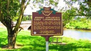
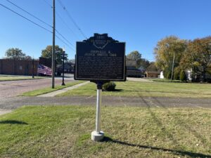
This is the site of Johnny Appleseed’s earliest known recorded landholdings. Appleseed (whose legal name was John Chapman) purchased two parcels from Joseph Walker on September 14, 1809: Mount Vernon town lot 147, upon which you stand, and lot 145, which is across the road and north of this site. Johnny Appleseed likely rested here on August 10, 1813, after arriving from Mansfield with alarming news of a rumored Indian attack. Appleseed returned to Mansfield with reinforcements from Mount Vernon that same day–a round trip of over fifty miles.
Public park at the Intersection of North Main Street and West High Street
Mount Gilead
, OH
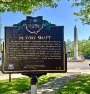
The Ohio War Savings Committee presented the Victory Shaft to the people of Morrow County for winning a special statewide campaign held during the summer of 1919. The contest involved buying war savings stamps, issued by the U.S. Treasury Department, that helped to finance America’s participation in World War I. The stamps allowed citizens, regardless of wealth or age, to contribute directly to the war effort and encouraged the importance of savings and thrift. Sold as a good return on investment, the tax-free stamps could be accumulated while earning four percent interest compounded quarterly. An estimated 10,000 people attended the Victory Shaft dedication on December 4, 1919. Keynote speakers at the event included Morrow County natives, Ambassador William Graves Sharp and Senator Warren G. Harding. (Continued on other side)
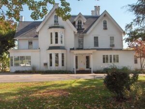
Lakeholm was built as the home of Columbus Delano while serving as Secretary of the Interior under President Ulysses S. Grant from 1870 to 1875. Delano (1809-1896) came to Mount Vernon in 1817, attended public schools, studied law, and was admitted to the bar in 1831. In addition to practicing law in Mount Vernon and serving as the Prosecuting Attorney of Knox County, Delano was a farmer, mill owner, and politician. Lakeholm, originally part of a 300-acre farm, contains many of its original rooms and Italianate features. In 1966, 209 acres of the farm were acquired for the establishment of the Mount Vernon Nazarene College. The house served as offices, meeting rooms, and classrooms. In 2002, the college became a university and continues to use Lakeholm for administrative offices. Historic Lakeholm is a focal point on the Mount Vernon Nazarene University campus and a symbol of the institution’s ties with the Mount Vernon community.
SW Corner of Sunbury Square near S. Columbus St & E. Granville St.
Sunbury
, OH
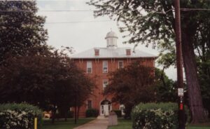
When Sunbury was platted in 1816, a town square was set aside for public use with the intention of constructing a town hall on the site. The first two stories of the Town Hall were built, as a school, in 1868 for $5,000. The Masons added the third story for $1,500 and occupied it for 91 years, until a lodge was constructed. Since 1868, the Town Hall has served Sunbury as a village office building, jail, fire station, and community library. Church services as well as Farmer’s Institutes were held in the building, and at one time it housed a bank. In 2002, the Town Hall was renovated for use as a community room and village offices.
Orrville was founded in 1852 at the railroad crossing that would later serve the Pittsburgh, Fort Wayne and Chicago and the Columbus, Mount Vernon and Cleveland railroads. The town was named in honor of Judge Smith Orr, who was instrumental in bringing the railroad to Wayne County. Orr persuaded landowner Robert Taggart to partition ten acres into town lots. After buying out the land owned by fellow settlers Christian Horst, David Rudy, and Peter Perrine, Orr engaged Jesse Straughan to create the first plat map that centered the newly-formed town on the railroad crossing. Incorporated on May 9, 1864, Orrville prospered and attracted manufactories of all kinds. Orrville was the largest manufacturing town in Wayne County by 1873.