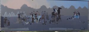
Native Americans inhabited and used much of the land in the Ohio valley as hunting grounds. As American settlers pushed west, conflicts resulted and attempts at peaceful settlement failed. Under political pressure, President George Washington resolved to subdue Indian resistance to American expansion in the Ohio country and appointed General Arthur St. Clair to lead the expedition. St. Clair’s troops camped on the Wabash River (just east of the Ohio-Indiana state line) after an exhausting two-month trek. The ill-prepared soldiers were no match for the forces of Miami, Shawnee, and Delaware Indians who attacked them at dawn of November 4, 1791. By the day’s end, warriors led by Little Turtle and Blue Jacket had killed or wounded nearly three-quarters of the American force-the worst-ever defeat of the U.S. Army by Native Americans in a single battle.
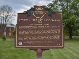
In the years leading to Ohio statehood in 1803, Ames Township citizens decided to establish a stock-owned circulating library. Since cash was scarce during Ohio’s frontier era, some citizens paid for their $2.50 shares by the sale of animal pelts, which were taken to Boston for sale in the spring of 1804 by merchant Samuel Brown. There he acquired fifty-one volumes, primarily books on history, religion, travel, and biography, as the first accessions for the Western Library Association. Senator Thomas Ewing later related that he paid his share with ten raccoon skins, thus suggesting the collection’s popular name “the Coonskin Library.” Judge Ephraim Cutler was the first of many librarians who kept the library until 1861.
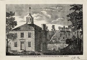
The first Northwest Territory assembly formally met in Cincinnati in September 1799 to initiate self-government. The legislators were deeply divided politically. The Republicans (antifederalists or “Jeffersonians”), led by Thomas Worthington and Edward Tiffin of Chillicothe, opposed the appointed government headed by the Federalist governor, Arthur St. Clair. They saw it as arbitrary and autocratic and recognized that change could occur only with statehood. To deter the movement, the St. Clair faction in 1801 divided the territory and removed the capital from Chillicothe to Cincinnati. Their actions triggered a violent confrontation led by the antifederalist Michael Baldwin who incited the local rabble-rousers, known as “the Bloodhounds,” to riot in the streets of Chillicothe. Both political unrest and advancing settlement accelerated the Chillicothe faction’s campaign for Ohio statehood.
Colonel Ebenezer Zane played a major role in the development of Ohio, a role that helped place it on the path to statehood. A veteran of the Revolutionary War and experienced road builder, he received permission from Congress in 1796 to build a road into the Northwest Territory, which would be called Zane’s Trace. In exchange for his work, Zane received land grants where the trace would cross the Muskingum, Hocking, and Scioto rivers. The trace began in Wheeling, West Virginia (then Virginia) and ended at Limestone, Kentucky (present-day Maysville) on the Ohio River. Opening in 1797, it brought settlement into Ohio, including Lancaster. Its route crossed the playground area of East Elementary from the northeast corner of today’s playground to the southwest corner, lot #18, East Addition, as recorded on an 1897 map of Lancaster.
The Wyandot called the Grand Reserve home nearly a century before Ohio statehood. They built houses, cultivated the land, and grew bountiful groves of fruit trees. They governed from the nearby Wyandot Council House and operated a productive saw and grist mill. Many sent their children to school and worshiped at the limestone church, built in 1824, and recognized as the first Methodist mission in the country. But Ohioans set their sights on Wyandot lands in the fertile Sandusky River Valley. State and federal governments were unwilling to allow the Wyandot to remain on their chosen homelands, despite their participation in American society and friendly relations with neighboring settlers. Following the Indian Removal Act of 1830, the Wyandot were the last tribe removed from the State of Ohio in 1843.
Rossville was settled in April 1801 shortly after the U.S. Government initiated land sales west of the Great Miami River. Its original proprietors–John Sutherland, Henry Brown, Jacob Burnet, James Smith and William Ruffin–named the town in honor of Pennsylvania Senator James Ross (1762-1847), who favored Ohio statehood and advocated free navigation of inland rivers. These founders envisioned Rossville as a shipping port for the rapidly growing population of farmers settling west of the Great Miami. The most practical outlet for their products was by flatboat down the Great Miami, Ohio, and Mississippi rivers to New Orleans. The town of Rossville was founded in 1804, the year after the Louisiana Purchase, which made the Mississippi River a United States possession. (Continued on other side)
Following the establishment of the public land system in 1785, the Continental Congress appointed a committee, chaired by James Monroe, to establish government in the new territory north and west of the Ohio River. Drafted prior to the Constitution of the United States, the Ordinance of 1787 provided the mechanism by which prospective states would enter the Union on an equal basis with existing states. It also prohibited slavery in the new territory and pledged good faith in dealing with Native American tribes. According to this plan, the Northwest Territory became the states of Ohio, Indiana, Illinois, Michigan, Wisconsin, and part of Minnesota in due course.
Western Reserve agriculturalist Charles Clement Jennings built the Casement House, also known as the “Jennings Place,” for his daughter Frances Jennings Casement in 1870. Designed by Charles W. Heard, son-in-law and student of Western Reserve master builder Jonathan Goldsmith, it is an excellent example of the Italianate style, featuring ornate black walnut woodwork, elaborate ceiling frescoes, and an innovative ventilation system. It remained in the Casement family until 1953. It was added to the National Register of Historic Places in 1979.