


, OH
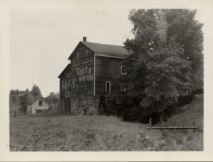
Fowlers Mill (originally Fowler’s Mills) developed around a group of mills built in the 1830s on the Chagrin River. Opportunities from these mills led to Fowlers Mill becoming the commercial center of Munson Township. From the 1830s into the twentieth century, the community expanded with construction of churches, a post office, township hall, stores, hotel, blacksmith shop, schools, and houses built in such styles as Federal, Greek Revival, Italianate, and Queen Anne. This type of community center was common in rural, nineteenth century America, but rarely survives with so much original fabric intact. On Mayfield Road, the Disciple Church was built in 1842. East of the church, the brick central school built in 1913 replaced earlier one-room schoolhouses. The gristmill is the only mill standing in Geauga County. The cemetery contains burials dating from the 1830s. The Fowler’s Mills Historic District was placed on the National Register of Historic Places in 2002.
, OH
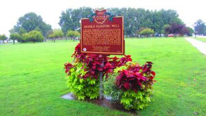
In 1791, Captain Jonathan Devol, upon a proposal from Griffin Greene, designed and built a floating grain mill, which was erected on two boats and anchored within several yards of the Ohio River shore near this marker. Oak planks fastened the boats together and formed a deck, upon which sat a frame building that enclosed the mill’s running gears and millstones. The mill’s position in a rapid portion of the river and its proximity to Farmer’s Castle, a fortification of thirteen blockhouses, built by local farmers at the beginning of the Indian Wars, shielded it from Indian raids. The river’s current revolved the wheel of the mill, and depending on the strength of the current, between twenty-five and fifty bushels of grain were processed in twenty-four hours. Devol’s floating mill replaced the hand mill, which had become too laborious to operate. The mill supplied meal to the garrison at Farmer’s Castle and other settlers along the Ohio River for a distance of nearly thirty miles.
, OH
Clifton Gorge is a classic example of a canyon cut into dolomite and shale bedrock that dates to the Silurian Period 400 million years ago. Created by meltwater released from the retreating continental glacier some 15,000 years ago, the cool, moist gorge has maintained a diversity of native plants, such as the red baneberry bush, that are now rare elsewhere in Ohio. The Little Miami River powered grist and cotton mills, paper factories, and breweries in the gorge during the nineteenth century. In 1973 the upper gorge became a state nature preserve.
, OH
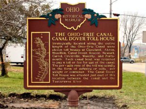
Strategically located along the entire length of the Ohio-Erie Canal were eleven toll houses at Cleveland, Akron, Massillon, Canal Dover, Roscoe, Newark, Carrol, Circleville, Waverly, and Portsmouth. Each canal boat was required to pay a toll or fee for use of the canal. The per-mile rate of the toll was usually in the form of pennies or mills, per weight or container. The Canal Dover Toll House was situated just east of this location between the canal and the Tuscarawas River.
, OH
In 1817 the United States government signed a treaty with a number of Native American tribes in northern Ohio, including the Seneca Indians. The Fort Meigs or Maumee Rapids Treaty bound the Seneca tribe to cede all claims to land north of the Greenville Treaty line, and in return they received a 40,000 acre reservation at Lower Sandusky (Fremont) and a $500 annuity to be paid each year in perpetuity. The reservation’s boundary began 1.5 miles north of here and extended 6.5 miles to the south. The width of the reservation was 8 miles with the western boundary at the Sandusky River. Beginning in 1830, with a policy of Indian removal developed by the administration of Andrew Jackson, tribes east of the Mississippi River were pressured to move to reservations in the West. The Seneca Indians moved to northeast Oklahoma in 1831.
, OH
Fowlers Mill (originally Fowler’s Mills) developed around a group of mills built in the 1830s on the Chagrin River. Opportunities from these mills led to Fowlers Mill becoming the commercial center of Munson Township. From the 1830s into the twentieth century, the community expanded with construction of churches, a post office, township hall, stores, hotel, blacksmith shop, schools, and houses built in such styles as Federal, Greek Revival, Italianate, and Queen Anne. This type of community center was common in rural, nineteenth century America, but rarely survives with so much original fabric intact. On Mayfield Road, the Disciple Church was built in 1842. East of the church, the brick central school built in 1913 replaced earlier one-room schoolhouses. The gristmill is the only mill standing in Geauga County. The cemetery contains burials dating from the 1830s. The Fowler’s Mills Historic District was placed on the National Register of Historic Places in 2002.
, OH
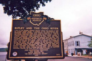
A part of the Virginia Military District, Ripley was founded in 1812 by Colonel James Poage, a veteran of the Revolutionary War. Originally named Staunton, after Poage’s hometown in Virginia, the village comprised 1,000 acres along the Ohio River. With its riverside location and deep water landing area, Ripley became a thriving community. Large quantities of flour, pork, and other goods were shipped from Ripley via flatboats down the Ohio. This continued as steamboats took over river trade and cargos came to include tobacco and other goods. Some of the goods leaving the area were shipped on vessels built in Ripley’s two boatyards. During the early and middle decades of the nineteenth century, the yards produced scores of flatboats and, during the peak years of 1826-1836, several steamboats. The boatyards were located on Ripley’s riverbank and lumber for boats came from surrounding forests. Red Oak Creek, running into the Ohio, was an especially favorable location for area mills and slaughterhouses.
, OH
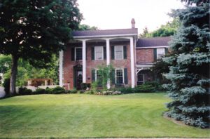
Jonathan Wright (1782-1855) and his wife Mary Bateman Wright (1787-1866) moved with their five children from Menallen, Adams County, Pennsylvania, in 1814 and built this Federal style house. Using skills acquired from his father, Joel Wright, a surveyor who platted the city of Columbus, Jonathan platted the village of “Springborough,” named for the many springs in the vicinity. The Wright family established and operated a woolen factory, two flour mills, a general store, and a 320-acre farm in the Springboro area. The Wrights were active members of the Society of Friends (Quakers) and strongly opposed slavery. The house was a station on the Underground Railroad, offering assistance to runaway slaves during their flight to freedom. Many members of the Wright family, including Jonathan, Mary, and four of their children, are buried in the Friends Cemetery on nearby Factory Road.