

, OH
Clinton County was a major center of activity for the Shawnee, Miami, and Delaware Indians. Early traces and trails developed as Indians traveled from village to village; gathered flint, salt and gold; traded furs, mica, and feldspar; and hunted bear, deer, otters, raccoons, foxes, wild cats, turkeys, and other wildlife. Trails throughout the county connected to other trails and villages in Ohio such as Lower Shawnee Town (now Portsmouth), Hurricane Tom’s Town (now Piketon), Chillicothe, Old Town (near Xenia), and Miami Town (now Dayton). Major trails or traces in Clinton County included the Bullskin, Wayne, Chillicothe, Delaware, Fort Ancient, Kanawha, Kenton and Todds Fork Traces. These routes were the avenues the first white settlers followed. (continued on other side)
, OH
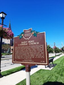
In 1839, Bishop John Baptist Purcell recruited European priests to minister to his Ohio flock. Father Louis Navarron, a young French missionary, was appointed to the French Catholic population of Darke and Shelby Counties in the area now marked by the villages of Russia, Versailles, and Frenchtown. St. Valbert, a centrally-located log church, was dedicated in December 1840 by Bishop Purcell to serve the region. In Russia, a log chapel was dedicated on Jean Jacques DeBrosse’s farm in 1846. Parish boundary lines were established in 1850, Precious Blood priests arrived, and a new church was dedicated to Saint Remigius in August 1852. As the congregation grew, so did the church buildings. The current Saint Remy Catholic Church, built between 1891-1892, was listed on the National Register of Historic Places in 1979.
, OH
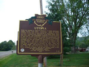
Utopia was founded in 1844 by followers of French philosopher Charles Fourier (1772-1837). Fourierism, based on utopian socialism and the idea of equal sharing of investments in money and labor, reached peak popularity in the United States about 1824 until 1846. The experimental community of Utopia dissolved in 1846 due to lack of financial success and disenchantment with Fourierism. John O. Wattles, leader of a society of spiritualists, purchased the land and brought his followers to Utopia in 1847. The spiritualists, who sought secluded areas to practice their religion, built a two-story brick house on the shore of the Ohio River. A flash flood on December 13, 1847, killed most of Wattles’ people. The majority of the few survivors left the area. Thus, the idea of the perfect society, or utopia, died. Henry Jernegan of Amelia, laid out the present village in 1847.
, OH
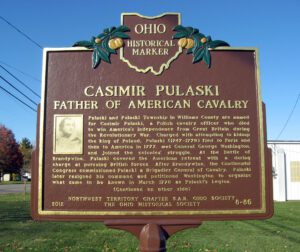
Pulaski and Pulaski Township in Williams County are named for Casimir Pulaski, a Polish cavalry officer who died to win America’s independence from Great Britain during the Revolutionary War. Charged with attempting to kidnap the king of Poland, Pulaski (1747-1779) fled to Paris and then to America in 1777, met General George Washington, and joined the colonies’ struggle. At the Battle of Brandywine, Pulaski covered the American retreat with a daring charge at pursuing British forces. After Brandywine, the Continental Congress commissioned Pulaski a Brigadier General of Cavalry. Pulaski later resigned his command and petitioned Washington to organize what came to be known in March 1778 as Pulaski’s Legion.
, OH
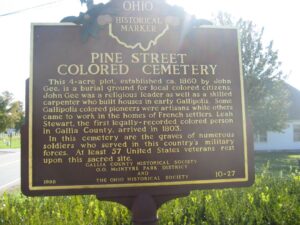
This 4-acre plot, established ca. 1860 by John Gee, is a burial ground for local colored citizens. John Gee was a religious leader as well as a skilled carpenter who built houses in early Gallipolis. Some Gallipolis colored pioneers were artisans while others came to work in the homes of French settlers. Leah Stewart, the first legally-recorded colored person in Gallia County, arrived in 1803. In this cemetery are the graves of numerous soldiers who served in this country’s military forces. At least 57 United States veterans rest upon this sacred site.
, OH
Unsatisfied by the terms of the treaty that ended the French and Indian War, Ottawa chief Pontiac led a confederacy of Native American tribes in attacks against British frontier forts during 1763, a campaign known as “Pontiac’s Conspiracy.” In October 1764, Colonel Henry Bouquet led a 1500-man army into the Ohio country from Fort Pitt (present-day Pittsburgh) as a demonstration of British force and to free captives held by several tribes. Informed of possible attack, Bouquet diverted his army overland from his Tuscarawas River valley route and here deployed his forces into three lines: a group of scouts on each ridge and the main force along present Route 93. Evidence of artillery emplacements and infantry breastworks remained visible for many years.
, OH
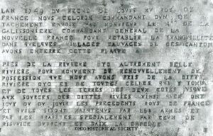
In 1749, the French in North America perceived a threat by British expansion west of the Allegheny Mountains to the Ohio River Valley and beyond. The French commander, Pierre Joseph Celeron, sieur de Blainville, with 250 men, left Montreal, New France, to establish French claims. They buried inscribed lead plates at the mouths of six important tributaries to the Ohio River. Three lead plates have been recovered, one was sent to England, and two are in American historical societies. The final plate was buried just west of here at the mouth of the Great Miami River, before the detachment turned north. However, after the British captured Montreal in 1760, French claims east of the Mississippi River were ceded to Britain by the 1793 Treaty of Paris. British Parliament annexed to Quebec (now Canada) and controlled all lands north of the Ohio River until 1776.(Continued on other side)
, OH
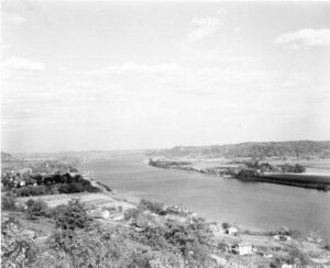
The Ohio River, the southeast border of Gallia County, played a significant role in the development of Gallipolis and Gallia County. One of the state’s first thoroughfares, this waterway enabled pioneers to settle in what was known as the Northwest Territory. On October 17, 1790, approximately 500 French immigrants arrived in Gallipolis, traveling by flatboats from Pittsburgh, and settled in log cabins in what is now City Park, in the heart of Gallipolis. This established the second oldest permanent settlement in the territory. The settlers relied on the River for communication, commerce, and transportation, and the River brought postal service to Gallipolis in 1794. As local business and river trade developed in the 1800s, Gallipolis became a thriving port. The scenic Ohio River is an important inland waterway, providing transportation for many commodities between major cities. The River also provides recreational opportunities for both visitors and residents, including water sports, fishing, and boating.