

, OH
Named for the 1903 co-inventors of the airplane, Wilbur and Orville Wright of Dayton, Ohio, Wright Field has been the center of aeronautical research, development, and weapon system acquisition since its establishment. Wright Field assumed this mission and was dedicated on October 12, 1927 after McCook Field (1917-1927), America’s “Cradle of Aviation” near downtown Dayton, closed its gates. ?Here on this ground where Wilbur and Orville Wright brought to full life man’s age-old dream of rising in flight above the earth, we of Wright Field consecrate ourselves to the splendid vision and unswerving purpose which motivated those great and honored pioneers of the sky. Their patience, their firm determination, their untiring devotion to their aim ” these we take as a light to guide and inspire us.” –Creed of Wright Field, December 17, 1942
, OH
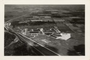
Known as the Norwegian Count, Nils Louis Christian Kachelmacher was born in Oslo, Norway of wealthy parentage. He immigrated to the United States at age 21 and was responsible for industrial growth in the Hocking Valley and expansion of the town of Logan. As president of the Columbus and Hocking Coal & Iron Company, Kachelmacher pioneered oil fields and developed holdings in iron, natural gas, and coal. He also directed the construction of the Greendale Brick plant, once considered the world’s largest brick producer. He died in 1917, bequeathing 10 acres of land to be used solely as a public park. He also established a trust to create an institution “solely to research the cure, prevention, and relief of varicose veins.” He once said, “It is my belief that each person should endeavor to make the world a little better because he lived and worked in it.”
, OH
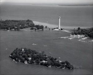
This 6.5 acre island, named for the resemblance of its dolomite ledges to the Rock of Gibraltar, was the likely observation site for Commodore Oliver Hazard Perry’s naval forces during the Battle of Lake Erie in September 1813. Stone Laboratory, located on both Gibraltar and South Bass islands, is the oldest freshwater biological field station and research laboratory in the United States. Founded in 1895 as the Lake Laboratory, it was named for Franz Stone, whose son Julius purchased the island from the Jay Cooke family and presented it to Ohio State University in 1925. It continues as the research and teaching laboratory for the Ohio Sea Grant College Program. The Jay Cooke Castle on the island is a National Historic Landmark.

, OH
Archibald Worthington (1818-1895) was a freed slave from Virginia, a Civil War veteran, and prominent landowner in Highland Township. Census records indicate he was manumitted prior to 1850, and by 1860 owned land in northwest Ohio. Worthington also farmed, boarded freed slaves, and owned apple orchards and livestock. April 1866 township records show that he supported the local school for Black families. He and his wife Elizabeth raised three children: Henry, Mathilda, and James. Henry enlisted in the Massachusetts 54th Volunteer infantry, one of the first Black regiments formed in the Civil War. He died January 8, 1865, in a prison camp and is buried in North Carolina’s Salisbury National Cemetery. Mathilda and James both met partners and married, had children, and left the area. Archibald Worthington died in 1895 and is buried in Wilmington’s Sugar Grove Cemetery.
, OH
Before and during World War II, the aviation industry was vulnerable to adverse weather conditions, particularly thunderstorms. In 1945, Congress mandated the nation’s first large-scale, scientific study of thunderstorms. The Thunderstorm Project was a cooperative undertaking of the U.S. Weather Bureau, Army Air Force, Navy, and the National Advisory Committee for Aeronautics (predecessor of NASA). The first phase of the project was conducted in Florida in 1946 and the second phase in Clinton County in 1947, partly because weather fronts frequently pass through this area. Pilots from the Clinton County Army Air Force Base made many flights through storms of varying intensities and all stages of development. (Continued on other side)
, OH
Agricultural development and cultivation on steep lands led to severe soil erosion in the nation in the 1920s and 1930s. In response, the United States Department of Agriculture established the Soil Conservation Service (SCS) in 1935. The SCS established the North Appalachian Experimental Watershed (NAEW) in the hills of Coshocton County to study and develop methods of conserving soil and water resources. The Federal government and Coshocton County purchased 1,047 acres of land for the program and, in 1936, field research equipment was installed and buildings constructed. The Works Progress Administration (WPA) and Civilian Conservation Corps (CCC) provided labor near the program’s inception, as did the Civilian Public Service Agency during World War II. (Continued on other side)
, OH
Stephen and Viola Armstrong moved their family, including 13-year-old Neil and his younger siblings, June and Dean, to the house at 601 West Benton Street in 1944. Here, Neil explored his fascination with flying by reading aviation magazines and building model airplanes. Neil completed flying lessons at nearby Port Koneta airport and earned his pilot’s license on his sixteenth birthday, even before receiving a driver’s license. Neil graduated from Blume High School in 1947 and studied aeronautical engineering at Purdue University on a Navy scholarship. The Korean conflict interrupted his studies, but he left the Navy as a decorated combat pilot, flying 78 missions. After graduating from Purdue in 1955, Neil worked at what would become the NASA Glenn Research Center in Cleveland. Soon after he became a test pilot at Edwards Air Force Base in California. (Continued on other side)
, OH
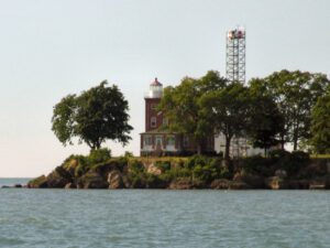
Constructed and first lit in 1897, the South Bass Island Light was in continuous operation until 1962 when the U. S. Coast Guard built an automated light tower to replace it. Significant for its contribution to transportation and commerce on Lake Erie, the South Bass Island Light was built to safely guide vessels through the crowded South Passage. Although many light stations were constructed with a dwelling as a separate structure, the keeper’s dwelling of the South Bass Light was attached to the 60-foot tower. The dwelling was designed in the Queen Anne style with red brick laid in Flemish bond. Outbuildings, a barn and oil house, were built in 1899. In 1967, The Ohio State University acquired the property for support of the F. T. Stone Laboratory programs for research, education, and outreach. South Bass Island Light was placed on the National Register of Historic Places in 1990.