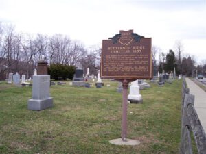
Isaac Scales (1786-1821) settled on this site. At his death, he was buried in his back yard. A large rock marked his grave. The land was reclaimed by Charles Olmsted who deeded it to the Township in 1835 for a public burial ground. Early settlers and veterans, who fought in six American wars including the Revolutionary, are buried here. The crypt was built in 1879.
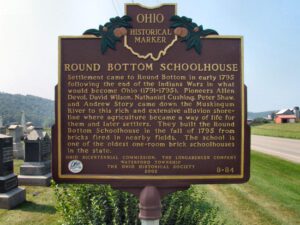
Settlement came to Round Bottom in early 1795 following the end of the Indians Wars in what would become Ohio (1791-1795). Pioneers Allen Devol, David Wilson, Nathaniel Cushing, Peter Shaw, and Andrew Story came down the Muskingum River to this rich and extensive alluvion shoreline where agriculture became a way of life for them and later settlers. They built the Round Bottom Schoolhouse in the fall of 1795 from bricks fired in nearby fields. The school is one of the oldest one-room brick schoolhouses in the state.
A prominent early 20th century illustrator and artist, Howard Chandler Christy was born on a farm in Morgan Township. He first gained notice as an illustrator during the Spanish-American War, but achieved lasting fame for his trademark “Christy Girls,” dream girls who idealized feminine beauty during this era. Between 1908 and 1915, he worked from a studio perched above the Muskingum River near Duncan Falls. In the 1920s Christy began to paint portraits and historical scenes. The Signing of the Constitution of the United States, displayed in the Capitol, is his most famous work. The Signing of the Treaty of Green Ville hangs in the Ohio Statehouse.
W side of intersection of Riverside Drive and Busenbark Road
Trenton
, OH
In 1833, Robert Busenbark deeded land to the directors of School District No. 6 for Busenbark School. Twenty years later, Robert and son David granted a right-of-way on their property for a station on the Cincinnati, Hamilton & Dayton Railroad (CH&D). One of eleven depots in Butler County, Busenbark station attracted the Kinsinger-Augspurger Warehouse and the Kennel Grain Elevator to the area in the 1860s. The railroad also enabled the cross-roads settlement to host an American championship prize fight in 1867. Fighting with bare knuckles in an outdoor ring, Mike McCoole bested Aaron Jones in a match seen by thousands. The Busenbark generating station supplied power to interurban lines until 1912 and later furnished electricity to local residents. Farmers and the Miami Poultry Yards depended on the trains and interurban to ship produce. The railroad depot disappeared between 1914 and 1916; the school closed after 1937; interurban service ended in 1939. All that remains of Busenbark is Busenbark Road, which was established in 1858.
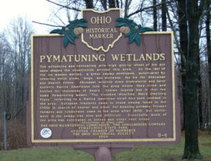
The advancing and retreating mile-high glacial sheet of ice and snow shaped the countryside around this area. As the last of the ice masses melted, a great swamp developed, punctuated by towering white pines, bogs, and wetlands, fed by the Shenango and Beaver rivers. Abundant wildlife drew prehistoric and later historic Native Americans into the area where they lived and hunted for thousands of years. Indian legend has it that the name Pymatuning means “The Crooked-Mouthed Man’s Dwelling Place,” referring to a Native American chief who once resided in the area. European trappers came to these swamp lands in the 1700s in search of beaver and other fur-bearing animals. Pioneer farmers and lumbermen came to the area after 1800, but settlement in the swamp was slow and difficult. Eventually much of the area was cultivated in onions and other root crops. (continued on other side)
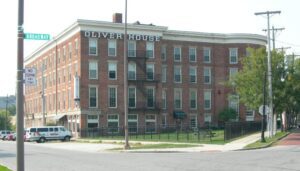
Overlooking the “Middlegrounds,” an early site of railroad, immigration, and commercial activity, the Oliver House opened in 1859 as Toledo’s premier hotel. It was designed by nationally prominent architect Isaiah Rogers, in the Greek Revival style, and built by the family of William Oliver for whom the hotel was named; owner of this land, Oliver was one of Toledo’s earliest real estate investors. (Continued on other side)
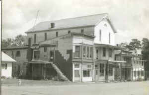
The commercial building that stood at 305 Main Street for over a century was built by Justus S. Law in 1897. On April 1, 1897, Law leased the Odd Fellows and Knights of Pythias joint-use of the third floor, rent-free, for 99 years after they completed its construction and added a slate roof to the building. Although the Pythians purchased the remainder of the building in 1921, they continued to share their “Castle Hall” with the Odd Fellows until 1965. In July 1974, the Pythians assigned their Pleasant City property to the Ohio Knights of Pythias Home in Springfield. From 1974 to 2012 the property exchanged private ownership multiple times until forfeited to the state in 2020. After the dilapidated Victorian building was demolished in 2021 the land was donated to the Village of Pleasant City.
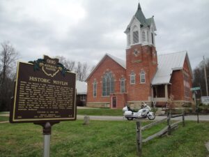
Mifflin was founded in 1816. Originally known as Petersburg, the name was changed in 1827 in honor of the settlers that moved here from Mifflin Township, Allegheny County, Pennsylvania. The first village jailhouse and crossroad watering trough are located here, on the grounds of the historic St. Michael Lutheran Church. Organized in 1835, the church built this house of worship in 1890. As early as 1810, stagecoaches traveled Mifflin’s main thoroughfare between Wooster and Mansfield, stopping at the watering trough, known for “the best spring water in Ohio”. In 1925, the trough was removed to allow room for the construction of the Lincoln Highway built in 1928. A Lincoln Highway “L” marker stands in the village today, in its original location, directing motorists eastbound.