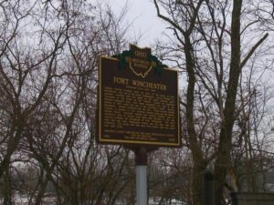
General William Henry Harrison ordered the construction of Fort Winchester at the beginning of October 1812 and it was completed October 15. The fort served as a forward observation post and supply depot for the American army during the War of 1812. Until Fort Meigs was completed in 1813, Fort Winchester was the front line against the British and their Indian allies. During the siege of Fort Meigs, Fort Winchester was a rendezvous point for the troops of General Green Clay and those of Colonel William Dudley. Fort Winchester outlined the shape of a parallelogram, measuring 600 by 300 feet in size. Blockhouses anchored the four corners of the fort and within its stockade were storehouses and a hospital.
Ripley was incorporated as the village of Staunton in 1812. Its name was changed in 1816 to honor General Eleazer Wheelock Ripley, a hero of the War of 1812. In the years before railroads, Ripley was a principal Ohio River shipping center. Also important were its extensive boat-building, tobacco, pork, and timber industries. Ripley too was the home of saw and planing mills, iron foundries, and a piano factory. Such varied commerce enabled Ripley to remain vibrant throughout the nineteenth century. Although noted as a port, Ripley is best remembered as an abolitionist stronghold. Many of its citizens, including Rev. John Rankin and John P. Parker, served as conductors on the famed “Underground Railroad.” The notoriety of Ripley’s anti-slavery network perhaps eclipsed that of nearby Cincinnati, earning the town a reputation as the “Black Hole of Abolitionism.” (Continued on side two)
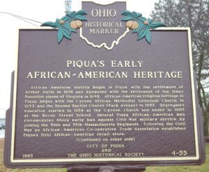
African-American history began in Piqua with the settlement of Arthur Davis in 1818 and expanded with the settlement of the freed Randolph slaves of Virginia in 1846. African-American religious heritage in Piqua began with the Cyrene African Methodist Episcopal Church in 1853 and the Second Baptist Church (Park Avenue) in 1857. Segregated education started in 1854 at the Cyrene Church and ended in 1885 at the Boone Street School. Several Piqua African-American men circumvented Ohio’s early ban against Civil War military service by joining the 54th and 55th Massachusetts Regiments. Following the Civil War an African-American Co-operative Trade Association established Piqua’s first African-American retail store. Continued on/from other side)
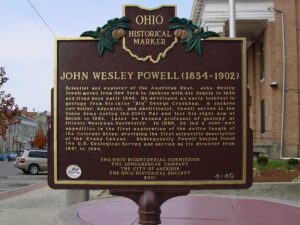
Scientist and explorer of the American West, John Wesley Powell moved from New York to Jackson with his family in 1838 and lived here until 1846. He developed an early interest in geology from his tutor “Big” George Crookham, a Jackson salt boiler, educator, and abolitionist. Powell served in the Union Army during the Civil War and lost his right arm at Shiloh in 1862. Later he became professor of geology at Illinois Wesleyan University. In 1869, he led a nine-man expedition in the first exploration of the entire length of the Colorado River, providing the first scientific description of the Grand Canyon. Subsequently Powell helped found the U.S. Geological Survey and served as its director from 1881 to 1894.
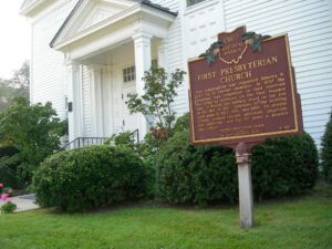
This congregation was organized January 9, 1820 by 11 charter members. In 1837 the structure was completed on land reserved for religious purposes on the first Maumee plat. A British gun battery stood on the site in the War of 1812. Additions to the building were made in 1922, 1951, and 1968. Dr. Horatio Conant, pioneer teacher, merchant, physician, and politician, was for 59 years a member and officer.
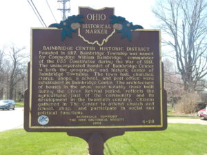
Bainbridge Center Historic District. Founded in 1817, Bainbridge Township was named for Commodore William Bainbridge, commander of the USS Constitution during the War of 1812. The unincorporated hamlet of Bainbridge Center is both the geographic and historic center of Bainbridge Township. The town hall, churches, stores, shops, a school, and post office were established in Bainbridge Center. The architecture of houses in the area, most notably those built during the Greek revival period, reflects the agricultural past of the community and its development in the twentieth century. Citizens gathered in The Center to attend church and school, shop, and participate in social and political functions.
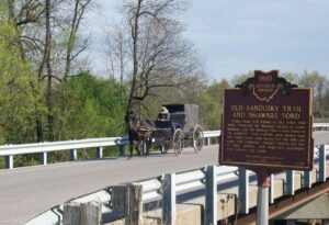
County Road 265 follows an old Indian trail which connected the Wyandot villages at Upper Sandusky with the Shawnee Mac-o-chee towns to the southwest. Many wigwams were pitched near this Scioto River ford during the late 18th and early 19th centuries. Soldiers (during the War of 1812), settlers, and stagecoach passengers later followed this route.
(1792-1862) A native of South Hadley, Massachusetts, he came to Gallipolis ca. 1818. An eminent lawyer and member of U.S. Congress 22 years, he was chairman of the House Ways and Means Committee during the Mexican War, founding father of the U.S. Department of the Interior, honored in his own time by the naming of Vinton County in 1850. Buried Pine Street Cemetery.