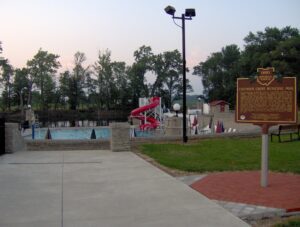
The construction of Putnam County’s first public swimming pool helped Columbus Grove weather the Great Depression of the 1930s. President Franklin D. Roosevelt’s Works Progress Administration (WPA) and the Village of Columbus Grove planned the pool to provide much-needed jobs and recreational facilities for the residents of Putnam County. Between the fall of 1935 and 1936, local men (and two women) built the pool and shelter house by hand from rock quarried on site. The workers were not trained stone masons or cutters. Befitting their limited skills, the pool was built in a simplified Norman Revival/Rustic architectural style. Wages ranged from $.33 to $.55 per hour. The pool’s grand opening was July 1, 1937. That first year, adults paid $.25 to swim, and children were charged $.10. The Columbus Grove Municipal Pool was listed on the National Register of Historic Places in 1997.
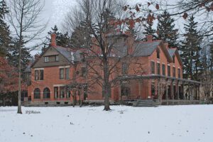
The twenty-five acre estate Spiegel Grove was the home of Rutherford Birchard Hayes, the 19th president of the United States. Spiegel Grove received its name from the German word “spiegel,” meaning mirror, describing pools that collect beneath the trees after a rainstorm. Hayes’s uncle, Sardis Birchard, a Fremont merchant, built the home on this site in 1863. The Hayeses moved to Spiegel Grove after Hayes’s second term as Ohio governor ended in 1873. They inherited the estate in 1874. The family left Fremont after Hayes’s election as Ohio governor in 1875, and U.S. president in 1876. They returned to Spiegel Grove in 1881. The Hayeses expanded the home in 1880 and 1889. Lucy and Rutherford Hayes died at Spiegel Grove in 1889 and 1893 respectively. They were reburied at Spiegel Grove in 1915. Their children donated the property to the state of Ohio in 1909 in order to establish the nation’s first presidential library.
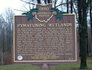
The advancing and retreating mile-high glacial sheet of ice and snow shaped the countryside around this area. As the last of the ice masses melted, a great swamp developed, punctuated by towering white pines, bogs, and wetlands, fed by the Shenango and Beaver rivers. Abundant wildlife drew prehistoric and later historic Native Americans into the area where they lived and hunted for thousands of years. Indian legend has it that the name Pymatuning means “The Crooked-Mouthed Man’s Dwelling Place,” referring to a Native American chief who once resided in the area. European trappers came to these swamp lands in the 1700s in search of beaver and other fur-bearing animals. Pioneer farmers and lumbermen came to the area after 1800, but settlement in the swamp was slow and difficult. Eventually much of the area was cultivated in onions and other root crops. (continued on other side)
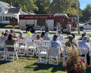
When inventor and entrepreneur Garrett Augustus Morgan sold his Traffic Signal patent to General Electric in 1923, he used the $40,000 to purchase a 121-acre farm in Huron County in 1924. Advertising “a village of our own,” Morgan established the Wakeman Country Club — one of Ohio’s early African American recreation clubs — and offered 247 lots for $60 each in “Wakeman Heights.” Located near the intersection of State Route 60 and Chenango Road, the development provided country pleasures to Blacks excluded from the Country Club lifestyle. Club membership, included in the purchase of a lot, offered fishing, hunting, swimming, and horseback riding. A restaurant, dance hall, and amphitheater provided cultural and boxing events. The club waned during World War II and no buildings from the once-thriving Wakeman Country Club remain.
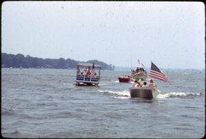
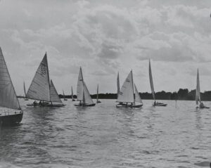
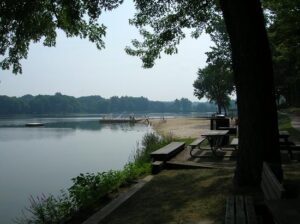
Using a four-mile long dam, the state of Ohio impounded the Licking Summit Reservoir in the mid-1820s to supply water for the Ohio and Erie Canal. In 1894, the state renamed it Buckeye Lake and developed it for recreational use. The Columbus, Buckeye Lake, and Newark Traction Company developed an “electric park” here, bringing in excursionists on interurban cars between 1904 and 1929 and creating one of the region’s most popular resorts. Hotels and summer cottages proliferated on leased ground. Nine acres in size, the park featured daily free admission during the summer. (continued on other side)
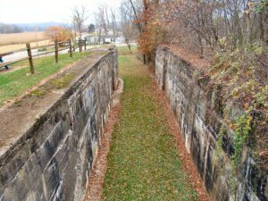
The Upper Trenton Lock (Lock 15 South) of the Ohio & Erie Canal was built between 1828 and 1829. Originally built of cut sandstone blocks, the lock was named for the Village of Trenton, now Tuscarawas. Lock 16, or Lower Trenton Lock, lies only 800 feet southwest of Lock 15. The lock tender, who lived in a house on this site, served both locks. Repeated flood damage prompted reconstruction of Lock 15 in 1907. The deteriorated stonemasonry was completely replaced with concrete at a cost of $6,815. The old stone was used to shore up the towpath. Use of the state-owned canal had declined significantly by this point, and the great flood of 1913 brought the canal era to an end in Ohio.
Formed by the retreating glacier more than 14,000 years ago, Buckeye Lake first existed as a shallow, swampy pond, named “Buffalo Swamp” by Ohio Company explorer Christopher Gist in 1751. Beginning in 1826 the State developed it as a water source for the Licking Summit of the Ohio and Erie Canal, it being the highest level between the Scioto and Licking rivers. Engineers dammed the north and west sides of the swamp, inadvertently creating a unique floating sphagnum-heath bog surrounded by water. Cranberry Bog, with boreal vegetation typical of glacial-era Ohio, is a registered National Natural Landmark. (continued on other side)
Silver Lake was previously known as Wetmore’s Pond, named for Judge William Wetmore, an agent for the Connecticut Land Company. In 1808, Wetmore built a cabin overlooking the spring-fed lake, which was then a part of Portage County. Local lore records his friendship and conscientious dealings with the Native Americans, likely Seneca, who inhabited a populous village between the lake and the Cuyahoga River. The tribe left the area to join the British during the War of 1812, but later sided with the United States.