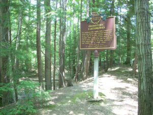
The prehistoric Erie Indians built a fortification across this neck of land sometime before 1650. A low wall is all that remains today of a stockade where earth had been piled at the base of posts. The stockade and the naturally steep embankments of the ridge provided a safe location for an Indian village.
Constitution Park-Just N of Intersection of OH 725 and US 42
Spring Valley
, OH
In 1779 John Bowman’s forces followed the east bank to Glady Run, then north to the Indian village of Old Chillicothe. In 1780 and 1782 militia commanded by George Rogers Clark, and guided by Simon Kenton and Daniel Boone, crossed the river and camped two miles north of Caesar’s Creek, then marched on the villages near Springfield, Piqua, and Bellefontaine.
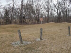
The Nettle Lake Mound Group consists of 4 low mounds overlooking a stream that runs into Nettle Lake. The mounds vary in height from 1 to 3 feet and in diameter from 18 to 30 feet. The mounds are composed primarily of reddish-brown sand (secondary mound) covering a layer of darker sand and loam (primary mound). These mounds have been partially excavated in the past by pot hunters in search of relics. Although the records of these excavations are vague and incomplete, pottery fragments, burials, and flint artifacts found in the mounds indicate that they were constructed by the Hopewell Indians.
The landscape of northwest Ohio was formed by melting ice and the glacial lakes left behind in its wake. Because of the low gradient (3 feet fall per mile) to the northeast, the flat lacustrine plain evolved into a large swamp. A massive swamp forest with huge hardwoods, broken only sporadically with intermittent wet prairies and savannahs, dominated the landscape. Both prehistoric and historic Indians farmed the flood plains of the Maumee River and its tributaries: Auglaize, Tiffin, and Blanchard rivers. (continued on other side)
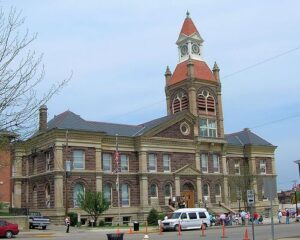
Established as the county seat of Pickaway County in 1810, Circleville derives its name from the circular portion of a large Hopewell-era earthwork upon which it was built. The Circleville earthworks, described in 1772 by Rev. David Jones for a Boston magazine, comprised an 1,100 foot diameter circle connected to a 900 foot square. Town director Daniel Dreisbach platted the town directly atop the earthworks, integrating the town plan into the prehistoric landscape. An octagonal courthouse stood directly in the center.
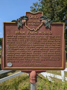
Built by people of the Adena or Hopewell cultures during the Early to Middle Woodland era (circa 800 B.C – 500 A.D), the Beam Farm Mound, 1200 feet northwest, has stood on the uplands overlooking Anderson Fork for two thousand years. Notable among the thousands of commemorative burial mounds built by these associated prehistoric cultures throughout the Ohio Valley, the Beam Farm Mound has been protected by its caretakers and remains unexcavated. Similar mounds have revealed formal tombs and evidence of elaborate funerary rituals.
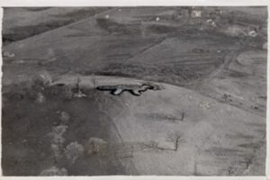
On this bluff lies one of the two great animal effigy mounds built by Ohio’s prehistoric people. Shown here, Alligator Mound is a giant earthen sculpture of some four-footed animal with a long, curving tail. Archaeologists believe the animal is perhaps an opossum or a panther, but not an alligator. The earthwork is approximately 250 feet long, seventy-six feet wide, and four feet high. Like the Great Serpent Mound in Adams County, Ohio, Alligator Mound is not a burial mound. The Newark Earthworks, built by the Hopewell people between 100 B.C. and A.D. 400, are three miles to the east. Scholars do not know who built Alligator Mound, but it may be the work of the Hopewell.
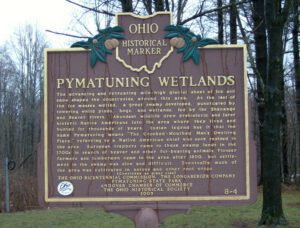
The advancing and retreating mile-high glacial sheet of ice and snow shaped the countryside around this area. As the last of the ice masses melted, a great swamp developed, punctuated by towering white pines, bogs, and wetlands, fed by the Shenango and Beaver rivers. Abundant wildlife drew prehistoric and later historic Native Americans into the area where they lived and hunted for thousands of years. Indian legend has it that the name Pymatuning means “The Crooked-Mouthed Man’s Dwelling Place,” referring to a Native American chief who once resided in the area. European trappers came to these swamp lands in the 1700s in search of beaver and other fur-bearing animals. Pioneer farmers and lumbermen came to the area after 1800, but settlement in the swamp was slow and difficult. Eventually much of the area was cultivated in onions and other root crops. (continued on other side)