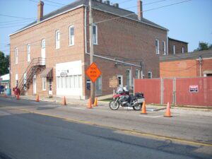
This building was a center of community life from the time of its construction in 1886 to the late 1930s. Once common, such combinations of governmental offices and commercial and entertainment space are today rare. The second floor opera house retains many original features, including stage backdrops, dressing rooms, and seats. Vaudeville, theater companies, and entertainment of all kinds were hosted here and many performers signed the backstage walls: Buffalo Bill dated his signature October 28, 1888. Along with village offices, first floor tenants have included the Vermillion Township Trustees, the Eddie Stover Hat Shop, and the F.L. Smith Watch Repair and Jewelry Store. Hayesville’s citizens approved the hall’s construction on April 18, 1884 by a vote of 100 to 13. Contractor Samuel Craig completed the building two years later at a cost of $4,852.20. Located on the Lincoln Highway, this building was listed on the National Register of Historic Places in 1976.
Tensions between Native Americans and Euro-American settlers remained high on the Ohio frontier during the War of 1812. Grievances mounted rapidly following the forced removal of the Greentown Delawares to Piqua in the late summer of 1812. On September 10, British-allied Indians attacked and killed the Frederick Zimmer family and neighbor Martin Ruffner one mile north of here. Five days later, on September 15, Reverend James Copus and three militiamen–George Shipley, John Tedrick, and Robert Warnock–were killed while defending Copus’ family from a raiding party one mile south of this site. (continued on other side)
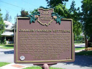
A pioneer in automotive innovation, Charles Franklin Kettering (1876-1958) was born three miles north of Loudonville. He attended local schools and graduated from Ohio State University in 1904. He organized the Dayton Engineering Laboratories Company (Delco) in 1909, which later became a part of General Motors (GM). “Boss Ket” served as vice-president of research for GM until 1920 and held over 140 patents (including four-wheel brakes, safety glass, and “ethyl” gasoline), achieving his greatest fame for an all-electric starting, lighting, and ignition system. The electric starter debuted on the 1912 Cadillac and was soon available on all cars, helping to popularize them with women. In 1945 he helped establish the Sloan-Kettering Cancer Research Institute in New York.
A migration of Indians throughout Ohio began due to unstable conditions created by the American Revolution. The massacre of Christian Indians at the Moravian mission of Gnadenhutten in 1782 and Colonel William Crawford’s expedition against Wyandot and Delaware towns along the Sandusky fueled insecurities. Delaware, including a small group of Mingo Indians, abandoned the village of Helltown, five miles southwest of this site, and settled Greentown as early as 1783. Greentown, situated on an elevation on the Black Fork beyond the clearing behind this site, was presumably named for British loyalist, Thomas Green. John Chapman (Johnny Appleseed) had an amicable relationship with the Delaware, owned land throughout the Black Fork Valley, and was known to visit Greentown on his travels throughout Ohio. Other visitors to the village included the Shawnee Prophet; Munsee Delaware leader, Captain Pipe; and local preacher, James Copus.
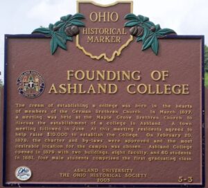
The dream of establishing a college was born in the hearts of members of the German Brethren Church. In March 1877, a meeting was held at the Maple Grove Brethren Church to discuss the establishment of a college in Ashland. A town meeting followed in June. At this meeting residents agreed to help raise $10,000 to establish the College. On February 20, 1878, the charter and by-laws were approved and the most desirable location for the campus was chosen. Ashland College opened in 1879 with two buildings, eight faculty, and 60 students. In 1881, four male students comprised the first graduating class.
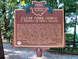
Clear Fork Gorge was formed when glacial meltwater cut through the sandstone bedrock that forms its steep walls fourteen to twenty-four thousand years ago. The gorge is one thousand feet wide and over three hundred feet deep. Its seclusion has preserved a rare forest community that includes native white pine and towering eastern hemlock. A National Natural Landmark, the gorge displays a wide variety of other tree species more common throughout the state, with sycamore on the bottomlands, beech, ash, and tulip farther up the slopes, and oak and maple on the ridges above. The gorge has changed little since pioneer legend Johnny Appleseed tended his apple orchards nearby.
John “Appleseed” Chapman (b. September 26, 1774—d. March 18, 1845) was the first lessee of this 160 acre tract (NW 1/4, S 20, T 20, R 16), when he secured it for 99 years from the Virginia Military District School Lands on April 10, 1815. This $320 lease complied with the Ordinance of 1785 which stipulated that proceeds from the sale or lease of a 36th of all new land in the Northwest Territory be used to support public education. Perrysville author, Rosella Rice, knew Appleseed. In a history of Ashland County, she wrote, “One of his nurseries is near us and I often go to the secluded spot on the quiet banks of the creek [Blackfork]…with sod never broken since the old man did it.” Attributed as Green Township’s first permanent settler, Abram Baughman’s original 160 acres (c. 1807) adjoined this property to the west.
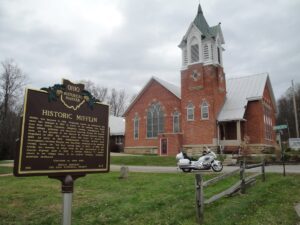
Mifflin was founded in 1816. Originally known as Petersburg, the name was changed in 1827 in honor of the settlers that moved here from Mifflin Township, Allegheny County, Pennsylvania. The first village jailhouse and crossroad watering trough are located here, on the grounds of the historic St. Michael Lutheran Church. Organized in 1835, the church built this house of worship in 1890. As early as 1810, stagecoaches traveled Mifflin’s main thoroughfare between Wooster and Mansfield, stopping at the watering trough, known for “the best spring water in Ohio”. In 1925, the trough was removed to allow room for the construction of the Lincoln Highway built in 1928. A Lincoln Highway “L” marker stands in the village today, in its original location, directing motorists eastbound.