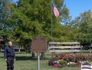
In 1772-73 missionary David Jones visited Blue Jacket’s Town, a settlement of 12 cabins downstream on the east bank and Pickaweekee, a Shawnee town, on the west bank. Deercreek Methodist Circuit Deacon, Dr. Edward Tiffin, met settlers after 1798. Dr. Tiffin was later elected first governor of Ohio. A station of Virginia bounty-land settlers, “Williams Town,” assembled here around 1797. Mill sites, established before Pickaway County, flourished in the dense oak forest of Deercreek Township. Frontier hotels in Williamsport prospered due to the “healthful” sulphur springs.
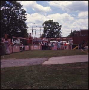
A. B. Graham, superintendent of Springfield Township Rural schools in Clark County, established the Boys and Girls Agricultural Experiment Club, which revolutionized agricultural education and non-formal youth development methods. The first meeting of the club, said to be the nation’s first farm club for young people, was held at this site on January 15, 1902 in the basement of the Clark County Courthouse. This was the start of what would be called a 4-H Club a few years later. Through the years, the overall objective of A.B. Graham and 4-H has remained the same: the development of youth as individuals and as responsible and productive citizens.
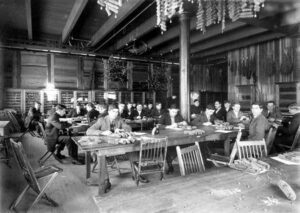
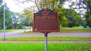
The Ohio General Assembly established the Ohio Agricultural Experiment Station in 1882. From its inception until 1892, the Station occupied 17 acres on the Columbus campus of The Ohio State University before relocating to 470 acres in Wayne County. In 1965, the Station changed its name to the Ohio Agricultural Research and Development Center (OARDC) to more accurately reflect its mission and programs. In 1982, the Center formally merged with The Ohio State University. Today, the Center encompasses nearly 2,100 acres in Wayne County with 10 branches located across the state for a total of approximately 7,100 acres dedicated to agricultural research.
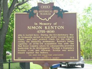
Simon Kenton who is buried here. During the Revolutionary War he frequently served as scout under George Rogers Clark, and later praised Clark for his role in saving the Kentucky settlements. Kenton’s Indian captivity of 1778-79 acquainted him with the Mad River Country where he subsequently provided leadership in its development. Though a legendary frontier scout and rifleman, Kenton was never biased against the Indians.
The West Liberty area, in the Mad River Valley, was the location of at least seven Shawnee Indian villages. This elevated site was the location of one of those villages. Several septs or divisions of the Shawnee nation lived in this area after being forced from their homes in southern Ohio. In 1786, together with Simon Kenton, Colonel Benjamin Logan’s army destroyed all the Shawnee villages in retaliation for the Indian raids in southern Ohio and Kentucky. Consequently, the remaining Shawnees moved to northwest Ohio near the present-day site of Maumee.
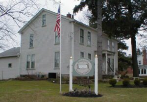
Originally called the James Thompson Inn, named for its builder, the son of Middlefield’s first settler, Isaac Thompson, the Batavia House is Middlefield’s oldest remaining structure. Built in 1818, the two-story wood frame structure was operated continually as an inn by Thompson until his death in 1877. It became the private residence of his daughter, Caroline, until 1907 when again it became an inn, functioning as the Century Inn until 1951. The one-story cement block portion was added circa 1950 to accommodate the weight of the heavy printing presses of the Shetler Printing Company, which occupied the building until 1983.
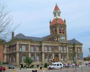
Established as the county seat of Pickaway County in 1810, Circleville derives its name from the circular portion of a large Hopewell-era earthwork upon which it was built. The Circleville earthworks, described in 1772 by Rev. David Jones for a Boston magazine, comprised an 1,100 foot diameter circle connected to a 900 foot square. Town director Daniel Dreisbach platted the town directly atop the earthworks, integrating the town plan into the prehistoric landscape. An octagonal courthouse stood directly in the center.
Frances Rappaport Horwich was born in Ottawa on July 16, 1907, the daughter of Sam Rappaport, an Austrian immigrant who operated a general store, and Rosa Gratz Rappaport, a Russian immigrant. The youngest of six children, she attended the Ottawa elementary school and graduated from Ottawa High School in 1924. After high school, she attended the University of Chicago where she earned a bachelor’s degree in philosophy and taught first grade for three years. “Miss Frances,” as she was called, then earned a master’s degree from Columbia University in 1933 and a Ph.D. in 1942 from Northwestern University. From 1942 to 1952, she was involved in teaching and education development. The basic education she received in the Ottawa schools enabled her to achieve great skills and abilities. [continued on other side]