

, OH
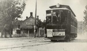
The Rapid Railway began operation in 1903 and was the Interurban Railway and Terminal Company’s (IR&T) northernmost traction line. The IR&T began near Pleasant Ridge and Kennedy Heights in Cincinnati and connected to a street car line that originated downtown, on Sycamore Street, and passed through a total of fourteen municipalities. The interurban cars ran down Main Street through Mason before turning south onto Dawson Street, crossing Muddy Creek, and traveling to Kings Mills. From Kings Mills, the line continued to Lebanon where it terminated. The full ride from downtown Cincinnati to Lebanon took approximately one hour and fifty minutes. (Continued on other side)
, OH
The intersection of Turney and Granger Roads, called German Corners in the 1800s, later became known as South Newburgh Centre. At its earliest Turney Road was known as State Road and then Fisher Road. Finally, it was named for Joseph Turney, area resident and two-term treasurer of the state of Ohio. Granger Road was named after John Albert Granger, a major pioneer landowner in the area and the third son of Gideon Granger, an original investor in the Connecticut Land Company and U. S. Postmaster General under Presidents Thomas Jefferson and James Madison. Located here are St. John Lutheran Church, school and cemetery, established by German settlers that settled this farm community. Nearby is the Garfield Heights Historical Society Museum in a house built in 1890 for the German teachers.
, OH
Crandall Park is the heart of the historic district and includes Fifth Avenue, Redondo Road, Catalina Avenue, and Tod Lane. Most of the district’s historic structures were built between 1904 and 1930, Youngstown’s heyday as an urban and industrial center. The district encompasses 92 houses, 32 outbuildings, a pavilion and rustic stone shelter in Crandall Park, and the concrete arch bridge carrying Fifth Avenue over the park. The North Heights Land Company and the Realty Guarantee Trust Company developed much of the neighborhood. Homes in the district were built for the city’s prominent industrialists and businessmen. The houses feature the work of architects Morris Scheibel, Charles F. Owsley, Fred Medicus, Barton Brooke, and Cook and Canfield and are distinguished by their grand scale, high-style design, spacious lots, landscaping, and orientation to the park or boulevard roads. (Continued on other side)
, OH
Designed by noted Detroit architect Albert Kahn (1869-1942), this 13-story Commercial Style building was contructed for the Mahoning National Bank in 1910 and opened in 1911. Advances in steel-frame structural systems and Kahn’s pioneering developments in fireproof reinforced concrete construction allowed buildings in America to soar to new heights. In 1925 the building’s width doubled with the addition of five bays. Rich exterior details consisting of piers joined by Renaissance-styled arches emphasize the verticality of the white terra cotta skyscraper. The windows have ornamental iron windowsill guards. The banking lobby retains much of the original lavish interior characterized by black walnut paneling, coffered plaster ceilings, and period light fixtures. The building was added to the National Register of Historic Places in 1980.
, OH
Born in Richmond, Virginia, Powhatan Beaty moved to Cincinnati in 1849, where he spent the majority of his life. Beaty enlisted as a private in the Union Army in June 1863, and two days later was promoted to first sergeant, Company G, 5th United States Colored Troops (USCT). All the officers of Company G were killed or wounded during an attack on Confederate forces at New Market Heights, Virginia, in September 1864. Beaty took command of his company, and for his valor received the Congressional Medal of Honor. Beaty was one of two African-Americans buried in Ohio to receive the Medal of Honor for service in the Civil War. He died on December 6, 1916, leaving two sons, attorney and state representative A. Lee Beaty and John W. Beaty. He is buried in Union Baptist Cemetery along with nearly 150 USCT veterans.
, OH
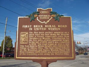
In the late nineteenth century, a movement to improve inadequate plank and dirt roads was brought on by the popularity of bicycling, the introduction of the automobile, and the need to improve travel to and from rural areas. Ohio, as a leader in the manufacture of brick paving blocks, was quick to upgrade roads. Toll roads were waning in popularity and the need for free roads was recognized. An act passed in 1892 authorized Cuyahoga County to levy a road tax. With funds levied, the Commissioners selected the Wooster Pike as one of three road improvement projects.
, OH
With its favorable seasons and fertile soils, the northern Ohio frontier attracted settlers to the Western Reserve from the beginning of the nineteenth century. With a well-established agricultural heritage, “truck farming” became popular as wagons hauled produce to stands at the Central Market on Public Square in Cleveland around 1860. Thirty years later, to extend the growing season, Martin Ruetenik, who was inducted into the Ohio Agricultural Hall of Fame, introduced the concept of greenhouse growing by constructing a 550-square foot greenhouse. Following his lead, nearly every farmer along Schaaf Road became a greenhouse farmer making Brooklyn Heights one of the leading greenhouse areas in the United States with over 4 million square feet or 100 acres “under glass.” With its concentration of greenhouse farming, Brooklyn Heights became synonymous with fine, high quality, greenhouse tomatoes.
, OH
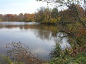
In 1822, Ralph Russell, a Connecticut pioneer who had settled in Warrensville Township ten years earlier, founded the North Union Shaker Community. The Shakers created Horseshoe Lake in 1852 when they built a dam across Doan Brook and harnessed its waterpower to operate a woolen mill near Lee Road and South Park Boulevard. The community disbanded in 1889; its 1,366 acres were eventually sold to a real estate syndicate from Buffalo, New York, the Shaker Heights Land Company. In 1896, this group deeded the Shaker Lakes Parklands to the City of Cleveland to preserve the green space in perpetuity. Ten years later, the Van Sweringen Company began to develop Shaker Heights Village as a Garden City suburb where William J. Van Aken served as mayor from 1915 until 1950. In the 1960s local residents successfully fought the proposed Clark Freeway, saving Horseshoe Lake and the Parklands from destruction.