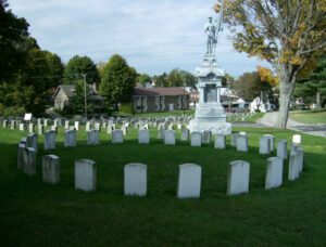
Envisioned as a rural cemetery with careful attention to landscaping design and symmetrical lots, the Riverview Cemetery was established in 1883 on forty acres of land. The chapel was a gift to Riverview from the Grand Army of the Republic, mostly Civil War veterans, and was dedicated on Memorial Day 1899. Plaques inside the chapel list 702 men from Ohio, Pennsylvania, and West Virginia who served in the Civil War, including 311 who are memorialized or buried at Riverview. There are also plaques listing soldiers killed in World Wars I and II, Korea, and Vietnam. The rich history of East Liverpool and Columbiana County is documented in the burials at Riverview Cemetery.
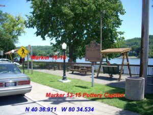
For nearly a century, East Liverpool dominated the United States pottery industry. Drawn to easily accessible clay deposits and ready river transportation, British-born potter James Bennett established the first commercial pottery here in 1841. His success drew other enterprising and innovative craftsmen, and by the Civil War era, the local industry was well established. During its peak production years (1865-1910), East Liverpool’s potteries produced and sold the majority of America’s crockery, with nearly the entire city’s population employed in the industry. Competition from imports and plastics, along with limited expansion space in the narrow Ohio valley, brought a decline in East Liverpool’s importance in the ceramics industry in the 20th century. Three large potteries continue the pottery tradition. The Ohio Historical Society’s Museum of Ceramics displays collections of early local ware.
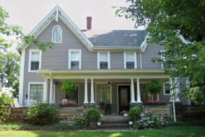
Unserheim, meaning “Our Home” in German, is the name of this ante-bellum Queen Anne style home, which was placed on the National Register of Historic Places in 1998. From 1857-1878, it was home to Daniel Howell Hise, a Quaker and ardent abolitionist. On April 8, 1849, Hise wrote, “Welcome! Welcome to the protection I can give, with or without the law.” A major stop on the Underground Railroad, Unserheim’s secret rooms and tunnel provided shelter to slaves on their flight to freedom. Hise’s belief in abolitionism was so strong that following John Brown’s Raid at Harper’s Ferry, he was instrumental in erecting the Edwin Coppock Monument at Hope Cemetery. Coppock had been executed for his participation in the raid. Hise also supported the Women’s Rights Movement and opened Unserheim to such notable guests as famed suffragists Susan B. Anthony and Sojourner Truth.
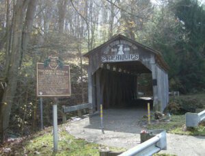
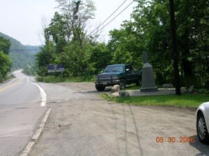
The Teegarden-Centennial Covered Bridge, constructed primarily of white oak is of Multiple King Post design spanning 67 feet. It was built nearly 100 years after the birth of the nation. Located on Eagleton Road, just off Teegarden Road, it is still at its original location, spanning the Middle Fork of the Little Beaver Creek in Eagleton’s Glen Park. It remained in use until 1992 when it was bypassed by a new concrete structure. The official contract for the construction of the bridge was awarded to Jeremiah C. Mountz in June of 1875. The stonework for the abutments was awarded to David Reese and painting of the original structure to George W. Akin in 1876. Members of Highland Christian Church came here to be baptized by immersion. There were over 250 covered bridges in Columbiana County, including at least 16 railroad covered bridges. The Teegarden-Centennial Covered Bridge is one of only five still remaining.
Fawcettstown, later to become East Liverpool, marked the first Ohio community to be encountered by early river travelers as they headed toward new challenges and new lives in the expanding nation. Indian canoes, flatboats, and steamboats carried increasing traffic, both passenger and freight, along these Ohio “Gateway” shores. Many of these early craft were built locally and local residents served as crewmen. Products from farms and ceramics from this city’s pioneer potteries were shipped from this site. The wharf area also served as a landing place for many of the early English potters who came here to ply their trades and, in the process, create a defining industry. The river continues to play an important role in industrial and recreational capacities.
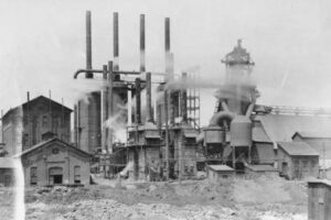
Believed to have been constructed in 1866, this facility is one of the largest of its kind in the nation. The complex of 200 ovens was erected by the Leetonia Iron and Coal Company, later known as the Cherry Valley Iron Works, to supply fuel for pig-iron producing blast furnaces that stood south of this site. The man-made “beehive” ovens were used to transform hard coal into coke. The “coking” process burnt impurities out of the coal. The end product — coke — was the best fuel source for the furnaces that were used to manufacture iron and steel. The facility discontinued operations in the early 1930s at the height of the Great Depression.
In April 1784, the Continental Congress adopted the Report of Government for the Western Territory, a broad plan drafted primarily by Thomas Jefferson for organizing the United States’ new western lands that were ceded by the states and purchased from Native Americans. One of the most far-reaching legislative acts in American history, the resulting Land Ordinance of 1785, passed on May 20th, established the public land system by which all federal land was surveyed and distributed. The Ordinance established a rectilinear survey system that divided land into townships of six miles square aligned by north-south and east-west baselines, and set aside certain lands for Revolutionary War veterans and for public schools.
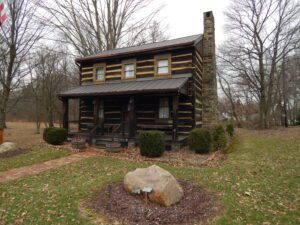
This circa 1840s log house, which now serves as a museum and home to the East Palestine Historical Society, was originally located at the corner of West Main and Walnut Streets. Some of its most notable and earliest residents were Dr. Robert Chamberlin (1798-1876), the town’s first resident physician, and his wife Rebecca (1810-1895). Chamberlin practiced medicine for 30 years, serving the town as a township trustee in 1834, the first postmaster in 1836, and township clerk in 1839. (Continued on other side)