Anson Williams visited Ohio in 1834 before he moved to Orange Township. A former resident of New York State, Williams purchased this site and the surrounding 1,000 acres of U.S. Military District lands and hoped to find opportunity for himself and his family. He bought the land for $6.00 an acre from James D. Wolf, who owned the 4,000-acre section three of Orange Township. The Village of Williamsville was laid out with 80 lots in 1836 on both sides of the Columbus and Sandusky Turnpike. Williams built his home and a hotel with a store and tavern. A hotel and tavern, owned by George Gooding and where the stage changed horses, had already been established north of Williamsville. Competition may have led to Williamsville’s decline. A church was built in 1845 and remained until 1900. Anson died in 1847, and his wife Hannah passed away in 1851. Both are buried in nearby Williamsville Cemetery.
The township of Kinsman was purchased by John Kinsman of Lisbon, Connecticut, in 1799 from the Connecticut Land Company. Kinsman has been the home of many notable citizens, some of whom include: Philip P. Bliss (1838-1876) and James McGrannahan (1840-1907) were hymn composers and religious musical directors for the nationally-known evangelical Dwight L. Moody Revival Meetings held in Kinsman for thirty years in the late 1800s. Clarence Darrow (1857-1938) was a famous labor and criminal lawyer who grew up in Farmdale and in the “octagon house” in Kinsman. Darrow in probably best known for his work as a defense attorney in the Scopes Trial. (continued on reverse side)
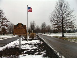
When inventor and entrepreneur Garrett Augustus Morgan sold his Traffic Signal patent to General Electric in 1923, he used the $40,000 to purchase a 121-acre farm in Huron County in 1924. Advertising “a village of our own,” Morgan established the Wakeman Country Club — one of Ohio’s early African American recreation clubs — and offered 247 lots for $60 each in “Wakeman Heights.” Located near the intersection of State Route 60 and Chenango Road, the development provided country pleasures to Blacks excluded from the Country Club lifestyle. Club membership, included in the purchase of a lot, offered fishing, hunting, swimming, and horseback riding. A restaurant, dance hall, and amphitheater provided cultural and boxing events. The club waned during World War II and no buildings from the once-thriving Wakeman Country Club remain.
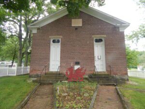
In 1972 a group of Welsh-Americans chartered the Welsh-American Heritage Museum to preserve Welsh history and culture, and to preserve the Welsh Congregational Church. The old brick church was where songs of praises rang, as the Welsh gathered and sang beloved hymns of their homeland in four-part harmony. The church is a link in a long, unbroken chain of memories and still serves the community as a center of Welsh-American activities and a keeper of the community’s heritage. The red dragon and daffodil are symbols of Wales.
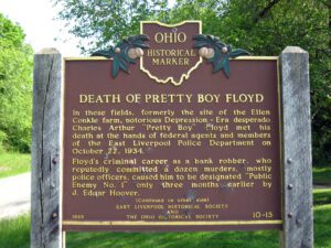
In these fields, formerly the site of the Ellen Conkle farm, notorious Depression-Era desperado Charles Arthur “Pretty Boy” Floyd met his death at the hands of federal agents and members of the East Liverpool Police Department on October 22, 1934. Floyd’s criminal career as a bank robber, who reputedly committed a dozen murders, mostly police officers, caused him to be designated “Public Enemy #1” only three months earlier by J. Edgar Hoover. (Continued on other side)
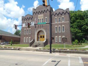
In the first years of the twentieth century, Athens’ citizens formed a new National Guard company. The guardsmen initially held drill at the Campbell Block on Court Street, but soon the Athens Commercial Club began advocating for an armory from the Ohio National Guard. In 1912, the Armory Board approved the request. Plans were drawn up for the armory and the Guard purchased land from the Athens Brick Company at the foot of Shale Hill. Construction began in the spring of 1915 and the Armory opened in December. In March of 1917, the city held a dedication ceremony and parade. Before World War I, the Athens Armory housed Company L and the Machine Gun Company, both part of the 7th Infantry Regiment, Ohio National Guard. (Continued on other side)
Orrville was founded in 1852 at the railroad crossing that would later serve the Pittsburgh, Fort Wayne and Chicago and the Columbus, Mount Vernon and Cleveland railroads. The town was named in honor of Judge Smith Orr, who was instrumental in bringing the railroad to Wayne County. Orr persuaded landowner Robert Taggart to partition ten acres into town lots. After buying out the land owned by fellow settlers Christian Horst, David Rudy, and Peter Perrine, Orr engaged Jesse Straughan to create the first plat map that centered the newly-formed town on the railroad crossing. Incorporated on May 9, 1864, Orrville prospered and attracted manufactories of all kinds. Orrville was the largest manufacturing town in Wayne County by 1873.
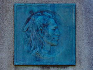
Tah-gah-jute, the Mingo chief named Logan, was a native of Pennsylvania. Logan moved to Ohio in 1770, and settled at the Pickaway Plains. Logan and his father, Shikellimus, had long supported friendships between Native Americans and white men; however, in the spring of 1774, his tribesmen and family were murdered at Yellow Creek, along the Ohio River. Once an advocate of peace, Logan went on the warpath and raided frontier settlements. These and similar raids along the Ohio frontier precipitated Lord Dunmore’s War in October 1774. After the Shawnees and their allies were defeated at Point Pleasant, Virginia governor Lord Dunmore marched up the Hocking River to the Pickaway Plains. Dunmore asked his interpreter, Colonel John Gibson, to assist in negotiations with Cornstalk and other Indian leaders, including Logan. Logan declined to attend the conference, but spoke to Gibson about his anger and betrayal.