

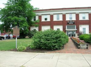
, OH
In 1910, the Ohio Electric Railway Company opened this terminal, formerly the Interurban Building, which served interurban passengers until 1937. Along with offices, it contained space for express and baggage handling, ticket windows, a newsstand, a lunch counter, and waiting rooms. Three tracks were laid at the rear of the building. At its peak, Ohio Electric radiated from Lima to Springfield, Toledo (via Ottawa), Defiance, and Fort Wayne. Its competitor, The Western Ohio Railway (“Lima Route”) connected Dayton and Toledo (via Findlay). The interurban network in and around Lima led to the creation of suburbs, linked industrial and residential areas, and promoted the creation of amusement parks and small lake resorts. With decreased passenger traffic due in part to personal automobiles and the Great Depression, the interurban and street railway era in Lima ended in 1939, 52 years after it had begun as Ohio’s first successful electric streetcar system.
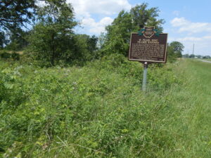
, OH
The W. Pearl King Prairie Savanna is a mostly undisturbed remnant of the once expansive Darby Plains Prairies. Prior to European settlement more than two centuries ago, the Darby Plains covered an area of more than 380 square miles west of Columbus. These prairies were an eastward extension of the Great Plains Prairie that Ohio State Professor Edgar Transeau termed the Prairie Peninsula in 1935. The W. Pearl King Prairie Savanna is a 20-acre vestige of a once large and varied habitat of native tallgrass prairie and oak groves. The prairie contains bur oaks, one of Ohio’s largest stands of prairie dropseed grass, and several other native prairie plants. Named for a former landowner, William Pearl King (1891-1960), the site has been owned and managed by Columbus and Franklin County Metro Parks since 2006.
, OH
Due to what is known as the Sharon Conglomerate or pebbly sandstone, these ledges have played an important role in the daily life of local residents and the economy. The porousness of this rock, which underlies much of Geauga County, supplies most of the county’s drinking water. Thompson Ledges also provided building stone with stone cutters working in quarries turning out doorsteps, watering troughs, gateposts, culverts, and bridges from mid-1800 to 1911 for use in Thompson, Geauga County and occasionally beyond. After 1900, cement became the preferred building material, but still used silica pebbles from the Ledges for gravel and cement. The Ledges have an unusual ecosystem containing several distinctive forests. A chestnut oak forest is pervasive on the top while a northern hemlock forest exists in the exposed creaks and crevices of the upper rim and ledges.
, OH
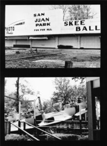
Nicknamed “Ohio’s Million Dollar Playground” or “Atlantic City of the Midwest,” Sandy Beach Amusement Park opened here on May 29, 1924. The park at Indian Lake featured a 2,000-foot long roller coaster and other popular rides, a boardwalk, and the Minnewawa Dance Hall. The Minnewawa and its succeeding dance pavilions hosted the greatest names of the Big Band era, and thousands of people came from all over Ohio to listen and dance to these popular entertainers. Societal turmoil and rioting in the 1960s affected the popularity of the park. Diminishing crowds, plus competition from larger theme parks such as Cedar Point and Kings Island, led to the park closing in the early 1970s. The lone remnant of the park is the steel arch bridge that spans the harbor.
, OH
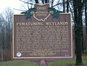
The advancing and retreating mile-high glacial sheet of ice and snow shaped the countryside around this area. As the last of the ice masses melted, a great swamp developed, punctuated by towering white pines, bogs, and wetlands, fed by the Shenango and Beaver rivers. Abundant wildlife drew prehistoric and later historic Native Americans into the area where they lived and hunted for thousands of years. Indian legend has it that the name Pymatuning means “The Crooked-Mouthed Man’s Dwelling Place,” referring to a Native American chief who once resided in the area. European trappers came to these swamp lands in the 1700s in search of beaver and other fur-bearing animals. Pioneer farmers and lumbermen came to the area after 1800, but settlement in the swamp was slow and difficult. Eventually much of the area was cultivated in onions and other root crops. (continued on other side)
, OH
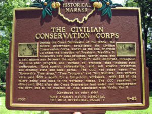
During the Great Depression of the 1930s, the federal government established the Civilian Conservation Corps, known as the CCC or triple C’s under the direction of President Franklin D. Roosevelt’s New Deal program. Nearly three and a half million men between the ages of 18-25 were employed throughout the nine-year program and worked on projects that included road construction, flood control, reforestation, and soil erosion prevention and creating state and local parks. The CCC had other names like “Roosevelt’s Tree Army,” “Tree Troopers,” and “Soil Soldiers.” CCC workers were paid $30 a month for a forty-hour workweek, with $25 of the salary being sent back to the workers’ homes. The CCC remained in effect until 1942 after the Great Depression had ended and unemployment was down due to the creation of jobs associated with World War II.
, OH
Edgerton was settled beside the St. Joseph River when the Lake Shore & Michigan Southern railroad was completed in 1854. The village was incorporated on December 4, 1865, and named for Alfred P. Edgerton, who donated the land for the park. He was an agent for Hicks & Company, a land speculation business. The firm of Von Behren & Shaffer built the town hall and opera house in 1884 for $7,998. The building and park became a hub of local activity. The park’s bandstand showcased the Edgerton Village Band and citizens gathered for picnics and festivities. (Continued on other side)
, OH
Using a four-mile long dam, the state of Ohio impounded the Licking Summit Reservoir in the mid-1820s to supply water for the Ohio and Erie Canal. In 1894, the state renamed it Buckeye Lake and developed it for recreational use. The Columbus, Buckeye Lake, and Newark Traction Company developed an “electric park” here, bringing in excursionists on interurban cars between 1904 and 1929 and creating one of the region’s most popular resorts. Hotels and summer cottages proliferated on leased ground. Nine acres in size, the park featured daily free admission during the summer. (continued on other side)