, OH
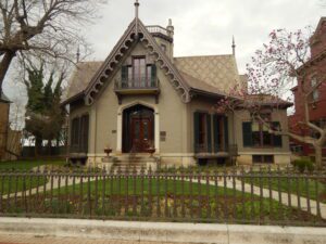
James Elrick, a local carpenter, built the Lane-Hooven House in 1863 for Clark Lane (1823-1907), a Hamilton industrialist and philanthropist. Lane, who first came to the area at age twenty-one as a blacksmith, resided in the house for more than eleven years. In 1866, Lane built the library, also originally an octagon, across the street. In 1868, he conveyed the library to the city. The C. Earl Hooven family resided in the house from 1895 to 1942. In 1943, Bertrand Kahn purchased the residence and presented it to the community for civic and charitable uses. It was donated as a memorial to his father, Lazard Kahn, a Hamilton industrialist and civic leader. The Lane-Hooven House was added to the National Register of Historic Places in 1973. (Continued on other side)
, OH
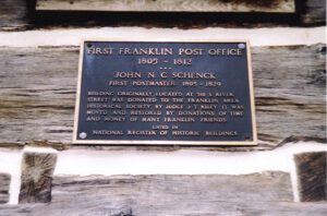
The oldest known structure standing in Franklin, the Old Log Post Office is a reminder of the links the community’s earliest members maintained to the rest of the young state of Ohio and to the United States during the early nineteenth century. John Noble Cumming Schenck, older brother of one of the founders of Franklin, William C. Schenck, established a store here in 1802. In 1805 President Thomas Jefferson appointed John Schenck postmaster of Franklin, a position he held until 1829. Schenck’s store is considered Franklin’s first post office and was one of the first four in Warren County. This building first stood at 310 South River Street and over the years was completely covered by additions and clapboards. They were removed in October 1974 and the house was moved to this location on December 6 of that year. In 1976 the structure was listed on the National Register of Historic Places.
, OH
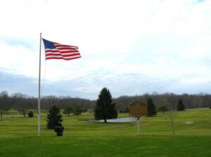
Golfer and World War II veteran William J. Powell, excluded from playing on many American golf courses because of his race, overcame the indignity of discrimination by creating his own course. Hand built in two years and opened in 1948, Clearview Golf Club is the first golf course in the United States designed, built, and owned by an African-American. The acclaimed course harmonizes with the landscape and bears many design elements of traditional British courses. A triumph of perseverance over discrimination, Clearview represents the historic postwar era when athletes first broke the “color line” in American sports.
, OH
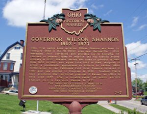
Ohio, first native-born governor, Wilson Shannon was born in February 1802 in the Mt. Olivet area near Barnesville. After attending Ohio University and studying law in Kentucky, he returned to Belmont County to practice and was elected county attorney in 1833. Shannon served two terms as governor of Ohio, from 1838 to 1840 and again from 1842 to 1844, resigning to accept a presidential appointment as minister to Mexico. After participating in the California Gold Rush, Shannon returned to Ohio and was elected to Congress in 1852. President Pierce then appointed him territorial governor of Kansas, an office he held until 1857. After a notable career of public service, Shannon died in Lawrence, Kansas, in 1877.
, OH
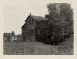
Fowlers Mill (originally Fowler’s Mills) developed around a group of mills built in the 1830s on the Chagrin River. Opportunities from these mills led to Fowlers Mill becoming the commercial center of Munson Township. From the 1830s into the twentieth century, the community expanded with construction of churches, a post office, township hall, stores, hotel, blacksmith shop, schools, and houses built in such styles as Federal, Greek Revival, Italianate, and Queen Anne. This type of community center was common in rural, nineteenth century America, but rarely survives with so much original fabric intact. On Mayfield Road, the Disciple Church was built in 1842. East of the church, the brick central school built in 1913 replaced earlier one-room schoolhouses. The gristmill is the only mill standing in Geauga County. The cemetery contains burials dating from the 1830s. The Fowler’s Mills Historic District was placed on the National Register of Historic Places in 2002.
, OH
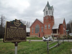
Mifflin was founded in 1816. Originally known as Petersburg, the name was changed in 1827 in honor of the settlers that moved here from Mifflin Township, Allegheny County, Pennsylvania. The first village jailhouse and crossroad watering trough are located here, on the grounds of the historic St. Michael Lutheran Church. Organized in 1835, the church built this house of worship in 1890. As early as 1810, stagecoaches traveled Mifflin’s main thoroughfare between Wooster and Mansfield, stopping at the watering trough, known for “the best spring water in Ohio”. In 1925, the trough was removed to allow room for the construction of the Lincoln Highway built in 1928. A Lincoln Highway “L” marker stands in the village today, in its original location, directing motorists eastbound.
, OH
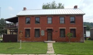
Named for General Zebulon Pike, killed in the War of 1812, Pike County was organized in February 1815. Commissioners were charged with establishing a county seat and on May 12, 1815 accepted a conveyance of 40 acres from Elisha Fitch. The new seat was named “Piketon.” In 1816, the commissioners let a contract for the construction of a courthouse and jail. A fine two story courthouse with brick laid in Flemish bond was finished in 1819. A fire destroyed some country courthouse offices on October 9, 1844. The repaired courthouse was the seat of county government until 1861 and is part of the Piketon Historic District, which was listed on the National Register of Historic Places in 1974. Limestone headers above the windows have the names of the county government offices.
, OH
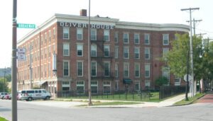
Overlooking the “Middlegrounds,” an early site of railroad, immigration, and commercial activity, the Oliver House opened in 1859 as Toledo’s premier hotel. It was designed by nationally prominent architect Isaiah Rogers, in the Greek Revival style, and built by the family of William Oliver for whom the hotel was named; owner of this land, Oliver was one of Toledo’s earliest real estate investors. (Continued on other side)


