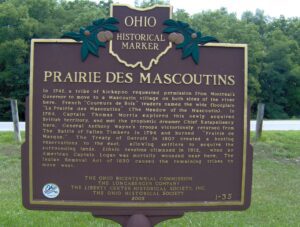
In 1742, a tribe of Kickapoo requested permission from Montreal’s Governor to move to a Mascoutin village on both sides of the river here. French “Coureurs de Bois” traders named the wide floodplain “La Prairie des Mascoutins” (The Meadow of the Mascoutin). In 1764, Captain Thomas Morris explored this newly acquired British territory, and met the prophetic dreamer Chief Katapelleecy here. General Anthony Wayne’s troops victoriously returned from The Battle of Fallen Timbers in 1794 and burned “Prairie de Masque.” The Treaty of Detroit in 1807 created a hunting reservation to the east, allowing settlers to acquire the surrounding lands. Ethnic tensions climaxed in 1812, when an American Captain Logan was mortally wounded near here. The Indian Removal Act of 1830 caused the remaining tribes to move west.
You are standing on the famous portage, carrying-place between the Cuyahoga and Tuscarawas rivers. The two streams and the portage across the watershed formed an early route between Lake Erie and the Ohio River. First the Indians, then French and English traders and trappers, and finally American settlers and travelers carried their canoes and packs across this narrow strip of land in passing, by way of the rivers, between northern and southern Ohio. The portage was a part of the defined boundaries in the treaties with the Indians made at Fort McIntosh (1785), Fort Harmar (1789), and Green Ville (1795). Use of the portage was discontinued in 1827 when the Ohio and Erie Canal was built along the old trail. Today, modern Akron streets–Portage Path and Manchester Road–follow the approximate route of the original portage.
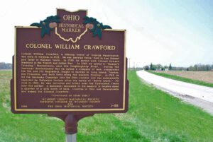
Colonel William Crawford, a lifelong friend of George Washington, was born in Virginia in 1722. He was married twice, first to Ann Stewart and later to Hannah Vance. In 1755, he served with Colonel Edward Braddock in the French and Indian war. In 1767, he moved to “Stewart’s Crossing,” Pennsylvania, near the Youghiogheny River. During the Revolutionary War he raised a company of men, commanded the 5th and 7th Regiments, fought in battles in Long Island, Trenton, and Princeton, and built forts along the western frontier. In 1782, he led the Sandusky Campaign into the Ohio country and was subsequently captured by Delaware Indians after the battle of “Battle Island.” On June 11, 1782, he was tortured and killed near the Tymochtee Creek near this marker. A monument dedicated to his memory is located about a quarter mile north of here. Counties in Ohio and Pennsylvania are named for Colonel Crawford.
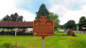
The ancient trail that passed near this spot was the major overland route entering the Ohio Country from the east through the 1700s. Also known as the Tuscarawas Path, the Great Trail was used by Native Americans, European explorers, fur traders, missionaries, military expeditions, land agents-and settlers after Ohio became a state. In January 1761, during the French and Indian War, Major Robert Rogers and thirty-eight rangers passed en route to Fort Pitt after taking Fort Detroit from the French. In 1764, during “Pontiac’s Conspiracy,” Colonel Henry Bouquet crossed here with an army of 1,500 men on his way to Goshachgunk (Coshocton), where he treated with the Delaware and freed captives. During the American Revolution, the Continental Army under General Lachlan McIntosh camped here for two days in November 1778.
Plunging herds of buffalo seeking salt licks and grazing lands wore trails through the Ohio Country when it was an Indian no-man’s land. Later, Indians found the same trails suitable for their needs. The tawny paths were highways as well as highest ways. Indians found ridges and summits superior to valleys for trails because they were drier, windswept of snow, never clogged by flood debris and safer.
Col. William Crawford and Dr. John Knight, separated from the American troops following the Battle of Upper Sandusky, June 4-5, were captured by Indians on June 7 at a site about five miles southeast of this marker. Taken first to Chief Wingenund’s camp north of Crestline, they were then taken, on a trail passing near this marker, to a bluff near Tymochtee Creek northwest of Upper Sandusky. Crawford was tortured and burned at the stake on June 11. Knight later escaped. For years afterward, Crawford’s fate inflamed frontier sentiment against the Indians.
Tensions between Native Americans and Euro-American settlers remained high on the Ohio frontier during the War of 1812. Grievances mounted rapidly following the forced removal of the Greentown Delawares to Piqua in the late summer of 1812. On September 10, British-allied Indians attacked and killed the Frederick Zimmer family and neighbor Martin Ruffner one mile north of here. Five days later, on September 15, Reverend James Copus and three militiamen–George Shipley, John Tedrick, and Robert Warnock–were killed while defending Copus’ family from a raiding party one mile south of this site. (continued on other side)
In the 1820s a general store and grist mill were established on this site, where the famous Scioto-Sandusky Indian trail neared the Sandusky River. The settlement was first known as McNutt’s, later as Swope’s Corners. The village of Fort Seneca was surveyed January 14, 1836. Its name was derived from Gen. Harrison’s War of 1812 fort, which was located a few miles downstream.